Postcard

Post and comment on screen captures from the beautiful game here. Home of the monthly screenshot competition

Postby Charl » Fri Oct 13, 2006 4:57 pm

Eventually drilled down through my bloated downloads folder to the White Island scenery addon.
Didn't read the readme as usual, and loaded up to fly...where?
Ah the extreme edge of the Taupo volcano chain.
'Ey?
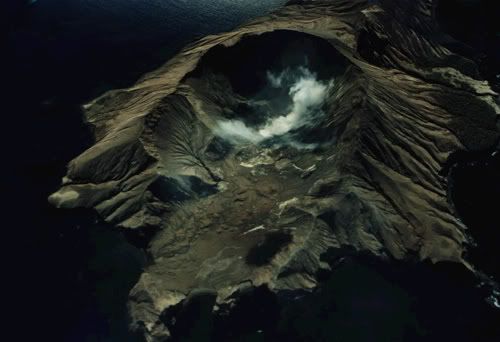
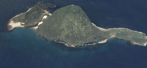
Out with the NZ Touring Map, ah...that little splot in the middle of the Bay of Plenty.
Right, crank up the faithful Beaver [Edit: oops I meant Otter, see below it's a DHC-3] floatplane as you can't land on the island.
Off from Tauranga, out there, and back to Whakatane.

user posted image

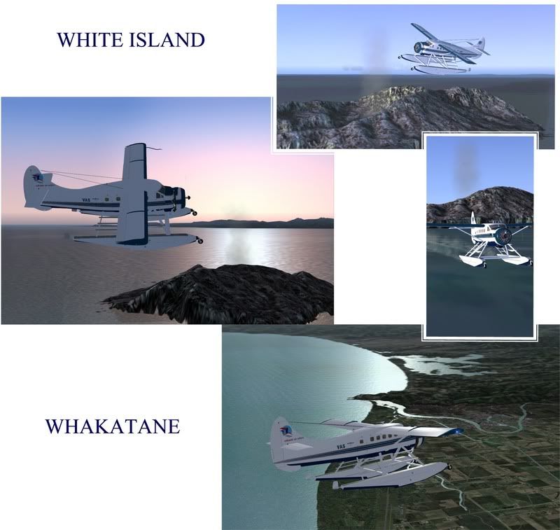
At 127 kts I must say it's not a journey lightly undertaken.
Good geography lesson, though, if the earth had burped just a little harder, there would be no BOP and NZ would've had 100,000,000 Ha extra land from Mayor Is all the way to Cape Runaway.

Thanks for the addon, Dorian, worth going all the way!
Last edited by Charl on Fri Oct 13, 2006 10:48 pm, edited 1 time in total.
User avatar
Charl
NZFF Pro
 
Topic author
Joined: Mon May 01, 2006 8:28 am
Posts: 9691
Location: Auckland

Postby Naki » Fri Oct 13, 2006 8:56 pm

Hi Charl

Great shots - have done the trip myself - by the way it is a Otter not a Beaver. I have seen the real Otter in Rotovegas - big beast for a single engine aircraft.

Cheers

Naki
User avatar
Naki
NZFF Pro
 
Joined: Sat Aug 05, 2006 10:03 pm
Posts: 7170
Location: Tauranga

Postby AlisterC » Sat Oct 14, 2006 7:37 am

Very nice!
Image
User avatar
AlisterC
NZFF Pro
 
Joined: Thu Jul 20, 2006 11:13 am
Posts: 2543
Location: Nelson, NZ

Postby Alex » Sat Oct 14, 2006 12:39 pm

Great pics, say, where did you get that marvellous looking aircraft from? :P

Alex
Alex
NZFF Pro
 
Joined: Fri Jul 14, 2006 3:39 pm
Posts: 3620

Postby Charl » Sun Oct 15, 2006 8:57 am

Base model is dhc3pzl.zip at AVSIM by Eugene Heyart
This Otter is the 1000hp conversion from Airtech Canada ®.
With 400 more horsepower than the original P&W R1340, the 1000 hp PZL engine offers significant performance gains


Still flies like a brick, the original must've been frightening.

Steve Jenks did an exclusive repaint of the VAS plane from your neighbourhood, for GNZLAP Pack 2. (gnzlap22.zip)
It was designed to coax online flyers like yourslf, to dip the toe into AI waters.
User avatar
Charl
NZFF Pro
 
Topic author
Joined: Mon May 01, 2006 8:28 am
Posts: 9691
Location: Auckland

Postby Alex » Sun Oct 15, 2006 10:52 am

Ah, ok well I'll check it out. <_<

Alex
Alex
NZFF Pro
 
Joined: Fri Jul 14, 2006 3:39 pm
Posts: 3620

Postby Timmo » Tue Oct 31, 2006 3:25 pm

This may be cheating a bit but here are a couple of images from ArcGlobe of White and Whale Islands.....
If only i had the knowledge to get these into Flightsim


user posted image
user posted image

As an aside, im just running the freeware mesh with the updated (free) landclass but Whakatane doesnt look as good as yours charl? Especially the definition of the river? do you have an addon river package?

(Edit: just thought id add: ArcGlobe costs $10 000 per license in NZ as its a professional 3d GIS pacakge: there is no dynamic lighting, shading, fog, mist, clouds etc etc etc.......as well as the fact that obtaining data to make a 3d project is very expensive...it makes you realise how lucky we are with Flightsim and the various (relatively) cheap data (ie the 20m mesh)
Further, some of the images look a bit bung because i just draped them over our 35m grid which includes the bathymetry data (i.e. it keeps sloping down from the shoreline)
Last edited by Timmo on Tue Oct 31, 2006 3:32 pm, edited 1 time in total.
Timmo
NZFF Pro
 
Joined: Wed Oct 25, 2006 6:28 pm
Posts: 2056
Location: Tauranga

Postby Charl » Tue Oct 31, 2006 4:13 pm

do you have an addon river package?

You really need to connect with Christian Stock, Timmo.
I run the RBE 20m mesh + topo package, and it produces some really excellent results.
I have custom textures which I've fiddled with also, but again it's Christian's NZ landclass that makes it all come alive.
It must've been a big decision he made, to go for it - as you point out geospatial data is anything but cheap.
But NZ is priviledged to have a real country in the FS world, not many can lay claim to that.
User avatar
Charl
NZFF Pro
 
Topic author
Joined: Mon May 01, 2006 8:28 am
Posts: 9691
Location: Auckland


Return to Screenshots

Who is online

Users browsing this forum: Johnwag and 25 guests