Hi Guys,
I've been out of the loop for a wee bit now - more involved in the VATSIM side of things but I've decided to take on a small project (well I think its turned into be a rather major project) and thats repairing Queenstown Airport and bringing it up to its modern-day self. I have purchased and use AFX to re-align the runways as per the CAA co-ordinates and have used satellite pictures, cross referenced with my own images and live webcam images to draw in aprons and taxiways as accurately as possible. My AFX file at this point has over 500 reference markers and a whole heap of guidelines - all squared up and looking good - but there are some things lacking :-)
There are a few things I am unclear on at this point. I have Vector Land Class installed (and running - very awesome). Vector Land Class has drawn in a few roads ruffly aligned to where real world taxi-ways exist (one that runs from the southern edge of the main apron down towards Real Journey's) and another one that runs from the Fuel Farm to (ruffly) Over the Top Helicopters. Is it possible to exclude these roads from VLC?? Or is it easier to 'draw' something over the top of it somehow? Any advice there would be greatly appreciated. At this point I am keeping the VLC as the ground template as it is extremely good!
The second thing is: buildings. Are there a set of buildings which I can grab from somewhere and slap some textures on and be done with it? Do I need to use GMAX (cringes) - I am not the best 3D modeller unfortunately. Is it possible to use buildings (with permission) from Peter Lohr's scenery created some time ago? Are there a wide-variety of items such as fuel tanks, fuel trucks and eye cander libraries out there available to use? What program would you recommend to help place and orientate+scale these buildings/eye candy?
One thing I do have a lot of is patience - any help would be greatly appreciated. Thanks
Leon.
Queenstown Re-construction
11 posts
• Page 1 of 1
![]() by Nzeddy » Fri Sep 02, 2011 10:19 pm
by Nzeddy » Fri Sep 02, 2011 10:19 pm
Just to let you know that Orbx is making Queenstown airport for FSX.
For the buildings, use Google Sketchup as it's very good for a beginner.
For the buildings, use Google Sketchup as it's very good for a beginner.
Last edited by Nzeddy on Tue Dec 06, 2011 12:45 am, edited 1 time in total.
- Eddy
-
Nzeddy - Sim-holic
- Joined: Thu Jun 12, 2008 7:52 pm
- Posts: 866
![]() by atc_unit » Fri Sep 02, 2011 10:23 pm
by atc_unit » Fri Sep 02, 2011 10:23 pm
Nzeddy wrote:QUOTE (Nzeddy @ Sep 7 2011,10:19 AM) <{POST_SNAPBACK}>Just to let you know that Orbx will be releasing Queenstown airport for FSX later this year along with NZ South Island. Payware.
For the buildings, use Google Sketchup as it's very good for a beginner.
Hi Nzeddy - thanks for the reply. I wasn't aware of this - very good. Do you know if there will be a lot of photoreal buildings etc? Also, regarding the use of Google Sketchup - how do I go about converting the models I make in Sketchup to a format ready for FSX? Can I use Sketchup to apply the textures at the same time? If this is the case - brilliant (I don't mind sketchup, I've used it for designing my custom PC case and bits and bobs). Is there some resources online you could point me to?
Thanks for your reply.
Leon.Leon Gibbs
VATNZ Deputy Director
NZ CPL(A)+MEIR, B-Cat
Stewart Island Flights - IVC
-
atc_unit - Member
- Topic author
- Joined: Sat Nov 18, 2006 4:09 pm
- Posts: 34
- Location: Invercargill, NZ
![]() by Nzeddy » Fri Sep 02, 2011 10:35 pm
by Nzeddy » Fri Sep 02, 2011 10:35 pm
Hi Leon,
Not sure but I guess they'll be. Just like their other airport scenery's.
This tutorial helped me to get Sketchup buildings into FSX: http://www.calclassic.com/sketchup_tutorial.htm
Another here in PDF format: http://www.fsdeveloper.com/wiki/index.php?..._using_SketchUp
You'll need:
Model ConverterX: http://agerrius.homedns.org/ModelConverterX/
Library Creator XML 2.0.3: http://www.fsdeveloper.com/forum/downloads...=file&id=93
Btw, you have the FSX SDK? The latest version is in the Acceleration disc.
Last edited by Nzeddy on Fri Sep 02, 2011 10:37 pm, edited 1 time in total.
- Eddy
-
Nzeddy - Sim-holic
- Joined: Thu Jun 12, 2008 7:52 pm
- Posts: 866
![]() by atc_unit » Fri Sep 02, 2011 10:38 pm
by atc_unit » Fri Sep 02, 2011 10:38 pm
Nzeddy wrote:QUOTE (Nzeddy @ Sep 7 2011,10:35 AM) <{POST_SNAPBACK}>Hi Leon,
Not sure but I guess they'll be. Just like their other airport scenery's.
This tutorial helped me to get Sketchup buildings into FSX: http://www.calclassic.com/sketchup_tutorial.htm
Another here in PDF format: http://www.fsdeveloper.com/wiki/index.php?..._using_SketchUp
You'll need Model ConverterX: http://agerrius.homedns.org/ModelConverterX/
Great thanks Nzeddy - Something to tinker with over the weekend. Anyone know of any popular object placement tools out there? I remember using Rwy12 Object placer years ago? Anything better?
Thanks.Leon Gibbs
VATNZ Deputy Director
NZ CPL(A)+MEIR, B-Cat
Stewart Island Flights - IVC
-
atc_unit - Member
- Topic author
- Joined: Sat Nov 18, 2006 4:09 pm
- Posts: 34
- Location: Invercargill, NZ
![]() by Nzeddy » Fri Sep 02, 2011 10:54 pm
by Nzeddy » Fri Sep 02, 2011 10:54 pm
I use Flight 1 Instant Scenery 2 (payware). So much easier because you can place objects while live in the sim. Also you can scale and rotate them, place at higher or lower altitude etc.
There are some freeware tools like Whisplacer and ADEX. Don't know if AFX can do this.
http://www.fsdeveloper.com/
There are some freeware tools like Whisplacer and ADEX. Don't know if AFX can do this.
http://www.fsdeveloper.com/
Last edited by Nzeddy on Fri Sep 02, 2011 10:58 pm, edited 1 time in total.
- Eddy
-
Nzeddy - Sim-holic
- Joined: Thu Jun 12, 2008 7:52 pm
- Posts: 866
![]() by toprob » Fri Sep 02, 2011 10:57 pm
by toprob » Fri Sep 02, 2011 10:57 pm
It is possible to exclude VLC roads, using exclusion polys creating in something like SBuilderX or Airport Design Editor. You just need to make sure that your airport sits at a higher priority than VLC.
For placement, I use Whisplacer, or you can use the OPT which comes with the SDK. Whisplacer is great once you figure out a work-flow which works for you.
If you have permission to use Peter's objects, then you could convert them to FSX using Model Converter X.
There are a lot of default FSX objects which you can include, certainly a lot more than were available for FS2004.
Last edited by toprob on Fri Sep 02, 2011 10:58 pm, edited 1 time in total.
-

toprob - NZFF Pro
- Joined: Sat Apr 29, 2006 4:56 pm
- Posts: 6716
- Location: Upper Hutt
![]() by atc_unit » Sat Sep 03, 2011 12:03 pm
by atc_unit » Sat Sep 03, 2011 12:03 pm
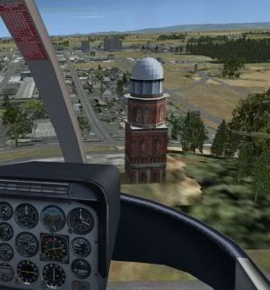
Excellent - thanks for all your help. I decided to do a wee test with Sketchup and look what I produced:
Textures are very ruff and I haven't spent more than about 1 hour on the whole thing but just goes to show how easy that was to do with Sketchup
Thanks guys - more questions to come I'm sure!
Textures are very ruff and I haven't spent more than about 1 hour on the whole thing but just goes to show how easy that was to do with Sketchup
Thanks guys - more questions to come I'm sure!
Leon Gibbs
VATNZ Deputy Director
NZ CPL(A)+MEIR, B-Cat
Stewart Island Flights - IVC

VATNZ Deputy Director
NZ CPL(A)+MEIR, B-Cat
Stewart Island Flights - IVC
-
atc_unit - Member
- Topic author
- Joined: Sat Nov 18, 2006 4:09 pm
- Posts: 34
- Location: Invercargill, NZ
![]() by dnkiwi » Sat Sep 03, 2011 8:08 pm
by dnkiwi » Sat Sep 03, 2011 8:08 pm
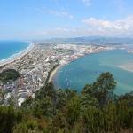
Hi Leon i can't wait to see some screenshot of your queenstown airport as i myself make trips up there alot to see what new helicopters are floating about and i love the pic with what looks like invercargill as i am from mataura and that looks very nicely placed

-

dnkiwi - Forum Addict
- Joined: Thu Dec 28, 2006 12:49 pm
- Posts: 267
- Location: Mataura
![]() by deeknow » Sat Sep 03, 2011 8:24 pm
by deeknow » Sat Sep 03, 2011 8:24 pm
Nice work Leon, keep at it mate, I doubt I personally will be going for the Orbx stuff for NZ so will be glad to see your work see the light of day
Deans repaints: http://www.deeknow.com/
X570 Mini-ITX m/b - Ryzen7 5700X3D (8c/16t) - RTX 2060-super - 32GB 3600MHz DDR4 - Win10 - P3Dv5.3
X570 Mini-ITX m/b - Ryzen7 5700X3D (8c/16t) - RTX 2060-super - 32GB 3600MHz DDR4 - Win10 - P3Dv5.3
-


deeknow - NZFF Pro
- Joined: Tue Sep 18, 2007 10:15 pm
- Posts: 4464
- Location: NZHN
![]() by Olderndirt » Mon Sep 12, 2011 1:30 pm
by Olderndirt » Mon Sep 12, 2011 1:30 pm
Since it's become my default home field and looks good in VLC, I anticipate your efforts with delight.

-
Olderndirt - Senior Member
- Joined: Wed Jan 05, 2011 2:36 pm
- Posts: 1774
- Location: Rochester, Washington USA
11 posts
• Page 1 of 1
Who is online
Users browsing this forum: No registered users and 19 guests