Napier Scenery ?
24 posts
• Page 1 of 2 • 1, 2
![]() by Jamessx » Fri Nov 12, 2010 4:11 pm
by Jamessx » Fri Nov 12, 2010 4:11 pm
Hey Guys I Am Desperate for some photo real textures for Napier every where else has photo real popping up except for Napier, why is this? And is there any photo real for Napier out there??
Last edited by Jamessx on Fri Nov 12, 2010 4:12 pm, edited 1 time in total.

-
Jamessx - Forum Addict
- Topic author
- Joined: Wed Apr 07, 2010 4:50 pm
- Posts: 196
- Location: Hawkes Bay
![]() by Ian Warren » Fri Nov 12, 2010 4:34 pm
by Ian Warren » Fri Nov 12, 2010 4:34 pm
There is some older Godzone you may find people wanting to sell (2004), i,m very sure something maybe in the magic scenery shop shortly 

-

Ian Warren - NZFF Pro
- Joined: Fri May 05, 2006 5:23 pm
- Posts: 41187
- Location: AREA 51
![]() by creator2003 » Fri Nov 12, 2010 4:41 pm
by creator2003 » Fri Nov 12, 2010 4:41 pm
I was doing Naiper and even had it layed down "until" last month i brought a new PC and burnt out now 3 hard drives which equaled 2500 gig of all my data 8 years of back ups which included everthing ive worked on or was working except my Hamilton Project ,though i nearly lost that to one morning .
After my stroke of bad luck over the last 3 months , i think ill look into it later once i have myself running again but its open area for anyone ,there is linz imagery source here in NZ which has naiper hastings right through to one corner of lake taupo ,3500 enclosed sq miles ,you will need some knowledge of GIS software ..
After my stroke of bad luck over the last 3 months , i think ill look into it later once i have myself running again but its open area for anyone ,there is linz imagery source here in NZ which has naiper hastings right through to one corner of lake taupo ,3500 enclosed sq miles ,you will need some knowledge of GIS software ..
-

creator2003 - NZFF Pro
- Joined: Fri Jun 16, 2006 12:08 am
- Posts: 4633
- Location: Cant U C im LOCO
![]() by Jamessx » Sat Nov 13, 2010 7:46 am
by Jamessx » Sat Nov 13, 2010 7:46 am
Nzeddy wrote:QUOTE (Nzeddy @ Nov 12 2010, 06:30 PM) <{POST_SNAPBACK}>Been working with this for at least 3 or 5 days. Still a WIP.
Im keen to do the Napier photoreal.


Eddy You Are My Idol, That Looks AwsomeLast edited by Jamessx on Sat Nov 13, 2010 7:47 am, edited 1 time in total.

-
Jamessx - Forum Addict
- Topic author
- Joined: Wed Apr 07, 2010 4:50 pm
- Posts: 196
- Location: Hawkes Bay
![]() by IslandBoy77 » Sat Nov 13, 2010 9:53 am
by IslandBoy77 » Sat Nov 13, 2010 9:53 am
I've been waiting for Napier stuff for a while too. Unfortunately, the LINZ stuff is ancient so I've been hoping someone would approach NCC or Regional Council to see if they would cough up some recent stuff (like, that has the Prebensen Drive extension in it at least) for cheap or free. The big prob with the old stuff is that it is missing a key feature just short of the south approach (34) of the runway - a major road extension called "Prebensen Drive". It's been there for a few year's now. However, anything 2004 or older doesn't even have the beginnings of the major roadworks that took place - works that radically altered the area which one has to fly over to land. Further, there is now a large housing development in that area called "Lagoon Farm" something-or-other, which has grown in leaps and bounds over the last 2-3 years. Call me picky, but if I'm gonna enjoy Napier photo-real, I'd like it to at least look like Napier today, not be a time-warp trip...  Know what I mean? Hence me not being in an overly large rush to have photo-real, knowing that much of the free stuff is just too old.
Not sure what age the stuff was that Mike was using. Eddy: what source imagery are you using, and how old is it?
Know what I mean? Hence me not being in an overly large rush to have photo-real, knowing that much of the free stuff is just too old.Not sure what age the stuff was that Mike was using. Eddy: what source imagery are you using, and how old is it?
Last edited by IslandBoy77 on Sat Nov 13, 2010 9:54 am, edited 1 time in total.
-

IslandBoy77 - Senior Member
- Joined: Tue Feb 03, 2009 2:23 pm
- Posts: 1020
- Location: Napier, New Zealand
![]() by toprob » Sat Nov 13, 2010 10:22 am
by toprob » Sat Nov 13, 2010 10:22 am
There is some recent imagery available as part of KiwImage, but although this was touted as the replacement for the LINZ project, it seems to be next to impossible to get hold of any images.
But Hawkes Bay is pretty well covered.
Here's an interesting bit from the KiwImage site:
But Hawkes Bay is pretty well covered.
Here's an interesting bit from the KiwImage site:
QUOTE
The New Zealand Defence Force(NZDF) are the custodians of the imagery on behalf of the agencies that have joined the project. To get access to the KiwImage products, you need to sign a Memorandum of Understanding (MOU) with the NZDF.[/quote]
Not quite the same as LINZ's great online images.
Not quite the same as LINZ's great online images.
Last edited by toprob on Sat Nov 13, 2010 10:26 am, edited 1 time in total.
-

toprob - NZFF Pro
- Joined: Sat Apr 29, 2006 4:56 pm
- Posts: 6741
- Location: Upper Hutt
![]() by Nzeddy » Sat Nov 13, 2010 10:35 am
by Nzeddy » Sat Nov 13, 2010 10:35 am
Jamessx wrote:QUOTE (Jamessx @ Nov 13 2010, 08:46 AM) <{POST_SNAPBACK}>Eddy You Are My Idol, That Looks Awsome
It's not what you think it is but the photoreal is just a background image to help me to design the AFCAD. So there won't be any high res image in my Napier AFCAD.IslandBoy77 wrote:QUOTE (IslandBoy77 @ Nov 13 2010, 10:53 AM) <{POST_SNAPBACK}>Eddy: what source imagery are you using, and how old is it?
I got the image from SBuilderX using Google Maps so I have no idea how old it is.
EDIT:
Yay.Last edited by Nzeddy on Sat Nov 13, 2010 11:04 am, edited 1 time in total.- Eddy
Nzeddy- Sim-holic
- Joined: Thu Jun 12, 2008 7:52 pm
- Posts: 866
![]() by NZ255 » Sat Nov 13, 2010 11:08 am
by NZ255 » Sat Nov 13, 2010 11:08 am
Have a look here Napier 2009 10cm per pixel
It's for sale at $0.56 to $6.40 per hectare so could end up being an expensive venture. Would be happy to lay it down if it's purchased.
Nick
It's for sale at $0.56 to $6.40 per hectare so could end up being an expensive venture. Would be happy to lay it down if it's purchased.
Nick
Nzeddy wrote:QUOTE (Nzeddy @ Nov 13 2010, 11:35 AM) <{POST_SNAPBACK}>What software did you use to lay down the photoreal Eddy?Nick
-

NZ255 - NZFF Pro
- Joined: Wed Jun 20, 2007 12:57 pm
- Posts: 2475
![]() by Nzeddy » Sat Nov 13, 2010 11:30 am
by Nzeddy » Sat Nov 13, 2010 11:30 am
NZ255 wrote:QUOTE (NZ255 @ Nov 13 2010, 12:08 PM) <{POST_SNAPBACK}>What software did you use to lay down the photoreal Eddy?
FWTools.
Looked at the Napier 2009 link and croped the image surrounding the airport. Came up to about $920. No thanks.Last edited by Nzeddy on Sat Nov 13, 2010 11:35 am, edited 1 time in total.- Eddy
-
Nzeddy - Sim-holic
- Joined: Thu Jun 12, 2008 7:52 pm
- Posts: 866
![]() by IslandBoy77 » Sat Nov 13, 2010 11:48 am
by IslandBoy77 » Sat Nov 13, 2010 11:48 am
Yep, the purchase-able stuff is expensive, alright. I spoke to NZAM about their stuff - got up in to the thousands of $ for just the immediate Napier city / airport area. They weren't interested in any deals for free, give-away sim work... 
Nzeddy wrote:QUOTE (Nzeddy @ Nov 13 2010, 11:35 AM) <{POST_SNAPBACK}>I got the image from SBuilderX using Google Maps so I have no idea how old it is.
According to Google, that particular tile is Jan 2005. The one south of it is July 2009.
-
IslandBoy77 - Senior Member
- Joined: Tue Feb 03, 2009 2:23 pm
- Posts: 1020
- Location: Napier, New Zealand
![]() by Nzeddy » Sat Nov 13, 2010 12:53 pm
by Nzeddy » Sat Nov 13, 2010 12:53 pm
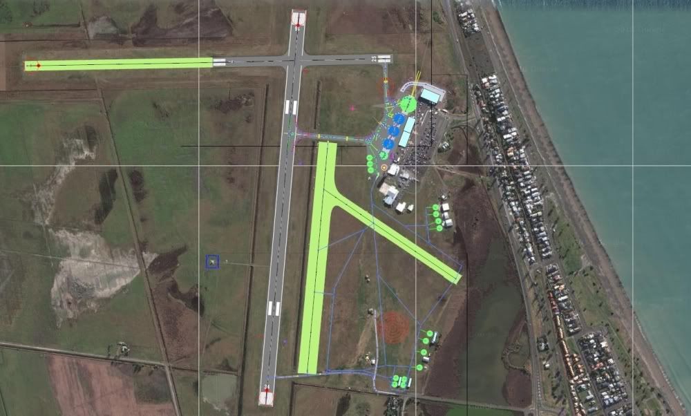
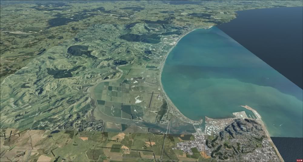
Ok, I'm planning to make this Napier scenery a free FSX project.
This will include photoreal coverage from Napier to Hastings, autogen and a highly detailed AFCAD with all the fancy taxilines etc.
If anyone can help that will be very great.
This will include photoreal coverage from Napier to Hastings, autogen and a highly detailed AFCAD with all the fancy taxilines etc.
If anyone can help that will be very great.
- Eddy
-
Nzeddy - Sim-holic
- Joined: Thu Jun 12, 2008 7:52 pm
- Posts: 866
![]() by Jamessx » Sat Nov 13, 2010 2:22 pm
by Jamessx » Sat Nov 13, 2010 2:22 pm
Nzeddy wrote:QUOTE (Nzeddy @ Nov 13 2010, 01:53 PM) <{POST_SNAPBACK}>Ok, I'm planning to make this Napier scenery a free FSX project.
This will include photoreal coverage from Napier to Hastings, autogen and a highly detailed AFCAD with all the fancy taxilines etc.
If anyone can help that will be very great.
Eddy That Would be excellent I can give you a hand if you need but im a noob at this sort of stuff

-
Jamessx - Forum Addict
- Topic author
- Joined: Wed Apr 07, 2010 4:50 pm
- Posts: 196
- Location: Hawkes Bay
![]() by Nzeddy » Sat Nov 13, 2010 2:52 pm
by Nzeddy » Sat Nov 13, 2010 2:52 pm
kcgb wrote:QUOTE (kcgb @ Nov 13 2010, 02:15 PM) <{POST_SNAPBACK}>hopefully there is a cheap source you can use, cause you cant use google images.
It's not what you think it is but the photoreal is just a background image (google image) to help me to design the AFCAD. So there won't be any Google high res imagery in my Napier AFCAD.Jamessx wrote:QUOTE (Jamessx @ Nov 13 2010, 03:22 PM) <{POST_SNAPBACK}>Eddy That Would be excellent I can give you a hand if you need but im a noob at this sort of stuff
Maybe some photos of the main airport buildings eg terminal, tower, hangers etc.- Eddy
Nzeddy- Sim-holic
- Joined: Thu Jun 12, 2008 7:52 pm
- Posts: 866
![]() by Nzeddy » Sat Nov 13, 2010 3:22 pm
by Nzeddy » Sat Nov 13, 2010 3:22 pm
Timmo wrote:QUOTE (Timmo @ Nov 13 2010, 04:18 PM) <{POST_SNAPBACK}>Eddy- Have a look on Koordinates.com as I think Napier is covered with a free LINZ aerial (slightly lower res but still fine for FSX)
Thanks for that but I'm already using LINZ aerial for big photoreal coverage.
http://www.linz.govt.nz/topography/aerial-...pv21/index.aspx
http://www.linz.govt.nz/topography/aerial-...bj39/index.aspx
Im using the Google image to help me with the AFCAD.Last edited by Nzeddy on Sat Nov 13, 2010 3:24 pm, edited 1 time in total.- Eddy
-
Nzeddy - Sim-holic
- Joined: Thu Jun 12, 2008 7:52 pm
- Posts: 866
![]() by Jamessx » Sat Nov 13, 2010 3:51 pm
by Jamessx » Sat Nov 13, 2010 3:51 pm
Nzeddy wrote:QUOTE (Nzeddy @ Nov 13 2010, 03:52 PM) <{POST_SNAPBACK}>It's not what you think it is but the photoreal is just a background image (google image) to help me to design the AFCAD. So there won't be any Google high res imagery in my Napier AFCAD.
Maybe some photos of the main airport buildings eg terminal, tower, hangers etc.
Sure Thing
-
Jamessx - Forum Addict
- Topic author
- Joined: Wed Apr 07, 2010 4:50 pm
- Posts: 196
- Location: Hawkes Bay
![]() by ZK-DWF » Sat Nov 13, 2010 7:33 pm
by ZK-DWF » Sat Nov 13, 2010 7:33 pm
My undertstanding is that the HB Scenery on Google Maps is from around 2005.
Somehow, Microsoft Bing has been able to get their hands on the latest sets, especially for Napier City. So, these are about a year old.
Somehow, Microsoft Bing has been able to get their hands on the latest sets, especially for Napier City. So, these are about a year old.
 ).
).-

ZK-DWF - Forum Addict
- Joined: Tue May 02, 2006 1:12 pm
- Posts: 271
- Location: Hastings, NZ
24 posts
• Page 1 of 2 • 1, 2
Who is online
Users browsing this forum: No registered users and 45 guests