Is there any software available for flightplaning?
In the process of doing a world tour but with a twist.
Im not using a modern aircraft
Flightplans
18 posts
• Page 1 of 1

![]() by kiwibarguy » Tue Nov 04, 2008 3:23 pm
by kiwibarguy » Tue Nov 04, 2008 3:23 pm
Hi there, i have a bit of experience with world tours as so do Naki and Towerguy who are two other well travelled gentlemen. I think one of the best tools to get (and this is for everyone) is the 'FSX objects for Google Earth'. It marks Airports, NDB's, Vors/Dme's for every airport,airfield, farm strip you can think of in your Google Earth. It's only about 2mb and you can click it on and off your google as you wish.
Download here> http://www.flightsimworld.com/downloads/viewfile/1726.html
Google Earth i think has been the essential tool for my tour. I can check the weather, see photos and links to places of interest, i can measure the distance and calculate my fuel more wisely. You can mark areas of freeware scenery that you find so you can make the trip visually more entertaining. But most importantly i can see the terrain and challenge my plane and give the viewer something to see if you wish to post.
Have a look at www.Simviation.com as they have a great range of tools under 'Utilities', they even have the 'FSX Super Flight Planner'. I have never tried it but it looks pretty big at 25mb for a utility.
Golden advice- What ever you do, dont rush your trip, i learnt that if you keep pushing yourself to do to much on your trip, it will end up being about getting to the finish line, and become a real chore and if that were the case, what would be the point in starting it at all. Do you want to get around and finish? NO! We want to enjoy the challenges of the environment, weather and conditions that present themselves and most importantly have fun flying planes. i think the thing i most enjoy about flying around the world is that the environment is consistently changing and it's all about the unknown!
I have been flying for a year and i'm still in Indonesia!

 Sorry if i have ranted on too much!
Download here> http://www.flightsimworld.com/downloads/viewfile/1726.html
Google Earth i think has been the essential tool for my tour. I can check the weather, see photos and links to places of interest, i can measure the distance and calculate my fuel more wisely. You can mark areas of freeware scenery that you find so you can make the trip visually more entertaining. But most importantly i can see the terrain and challenge my plane and give the viewer something to see if you wish to post.
Have a look at www.Simviation.com as they have a great range of tools under 'Utilities', they even have the 'FSX Super Flight Planner'. I have never tried it but it looks pretty big at 25mb for a utility.
Golden advice- What ever you do, dont rush your trip, i learnt that if you keep pushing yourself to do to much on your trip, it will end up being about getting to the finish line, and become a real chore and if that were the case, what would be the point in starting it at all. Do you want to get around and finish? NO! We want to enjoy the challenges of the environment, weather and conditions that present themselves and most importantly have fun flying planes. i think the thing i most enjoy about flying around the world is that the environment is consistently changing and it's all about the unknown!
I have been flying for a year and i'm still in Indonesia!
Sorry if i have ranted on too much!
-

kiwibarguy - Sim-holic
- Joined: Fri Sep 21, 2007 1:50 pm
- Posts: 629
- Location: Auckland
![]() by PiperDriver » Tue Nov 04, 2008 6:42 pm
by PiperDriver » Tue Nov 04, 2008 6:42 pm
You have a point about rushing things.
Its better to take it reasonable pace rather blitz through it in one hit.
The only difference with yours and Naki's is im going to use some alot older and its a 4 engine machine.
Lets hope that i doesn't break on the trip
Its better to take it reasonable pace rather blitz through it in one hit.
The only difference with yours and Naki's is im going to use some alot older and its a 4 engine machine.
Lets hope that i doesn't break on the trip
- PiperDriver
![]() by G-HEVN » Tue Nov 04, 2008 11:59 pm
by G-HEVN » Tue Nov 04, 2008 11:59 pm
For gross planning I use an old copy of Encarta Atlas 2001. It runs full screen, and has an extremely clean, clear presentation. Not sure it's still available though. For finer detail and fixing the actual route, I use a mix of FS and some software I've written myself. But in general, I'll use anything with the word "map" in the title, globes, wall charts, you name it.
- G-HEVN
![]() by towerguy » Wed Nov 05, 2008 7:23 am
by towerguy » Wed Nov 05, 2008 7:23 am
for the atlas I use an old copy of encarta 2000
for route planning etc I use old copies of the jeppesen charts and approach plates where I have them, and the flightsim planner where I don't.
Don't rush is good advice, there are times where you will get jaded and take a break from it - i.e . my tour for the last few months has been bogged down but I have started again and just have to type it up and get it out again.
good luck
CPU- i7 4790K @4.0Gb Cooler- Noctua NH-D15 M/B- Z97 ProGamer P/S- 750W RAM- 16Gb
Graphics- Nvidia GTX970 16Gb Drives- 2x 120Gb SSD Samsung 850EVO, 1x 2Tb HD, 1x DVD-RW
Sound- on M/B Logitec 5.1 surround sound system OS- Win 10 pro , all wrapped in a black Corsair case Display - Panasonic UHD 4k 50" Flatscreen TV.( 3840x2160 Res)
Graphics- Nvidia GTX970 16Gb Drives- 2x 120Gb SSD Samsung 850EVO, 1x 2Tb HD, 1x DVD-RW
Sound- on M/B Logitec 5.1 surround sound system OS- Win 10 pro , all wrapped in a black Corsair case Display - Panasonic UHD 4k 50" Flatscreen TV.( 3840x2160 Res)
-

towerguy - Sim-holic
- Joined: Mon Aug 07, 2006 4:27 pm
- Posts: 886
![]() by deeknow » Wed Nov 05, 2008 9:29 am
by deeknow » Wed Nov 05, 2008 9:29 am
Sound advice from the wise ones there. I'm also planning a tour at the moment. Got an aircraft in mind with decent range and speed so although I wont be rushing it too much, I'm also not gonna be taking too many diversions. Like PiperDriver I've also got an idea in mind for a theme for the tour.
One thing I'm wondering tho which I'm sure hits all world-tour planners at some point is how the hell do you cross the Pacific? The aircraft I'm gonna use should *just* about be able to hop across to Easter Island from Sth America but only if I drop into a Chilean military base/island along the way. Will have to get my little black book out and make some calls to people of millitary significance.
One thing I'm wondering tho which I'm sure hits all world-tour planners at some point is how the hell do you cross the Pacific? The aircraft I'm gonna use should *just* about be able to hop across to Easter Island from Sth America but only if I drop into a Chilean military base/island along the way. Will have to get my little black book out and make some calls to people of millitary significance.
Deans repaints: http://www.deeknow.com/
X570 Mini-ITX m/b - Ryzen7 5700X3D (8c/16t) - RTX 2060-super - 32GB 3600MHz DDR4 - Win10 - P3Dv5.3
X570 Mini-ITX m/b - Ryzen7 5700X3D (8c/16t) - RTX 2060-super - 32GB 3600MHz DDR4 - Win10 - P3Dv5.3
-

deeknow - NZFF Pro
- Joined: Tue Sep 18, 2007 10:15 pm
- Posts: 4484
- Location: NZHN
![]() by towerguy » Wed Nov 05, 2008 11:35 pm
by towerguy » Wed Nov 05, 2008 11:35 pm
the ONLY place really is SCIR or Robinson Crusoe
just google it or read on my tour (about the start of page 3)
it still leaves a hop of about 1600nm and usually a westerly as well!
cheers
just google it or read on my tour (about the start of page 3)
it still leaves a hop of about 1600nm and usually a westerly as well!
cheers
CPU- i7 4790K @4.0Gb Cooler- Noctua NH-D15 M/B- Z97 ProGamer P/S- 750W RAM- 16Gb
Graphics- Nvidia GTX970 16Gb Drives- 2x 120Gb SSD Samsung 850EVO, 1x 2Tb HD, 1x DVD-RW
Sound- on M/B Logitec 5.1 surround sound system OS- Win 10 pro , all wrapped in a black Corsair case Display - Panasonic UHD 4k 50" Flatscreen TV.( 3840x2160 Res)
Graphics- Nvidia GTX970 16Gb Drives- 2x 120Gb SSD Samsung 850EVO, 1x 2Tb HD, 1x DVD-RW
Sound- on M/B Logitec 5.1 surround sound system OS- Win 10 pro , all wrapped in a black Corsair case Display - Panasonic UHD 4k 50" Flatscreen TV.( 3840x2160 Res)
-
towerguy - Sim-holic
- Joined: Mon Aug 07, 2006 4:27 pm
- Posts: 886
![]() by Chairman » Thu Nov 06, 2008 10:31 am
by Chairman » Thu Nov 06, 2008 10:31 am
What do you do once you get to Easter Island ? There to Gisborne is still ~3600nm.
My Pacific plans normally involve island hopping to Hawaii then they hit a wall at the trip to North America. Leaving from Hilo PHTO instead of Honolulu PHNL trims almost 100 miles from the trip and you can knock another 100 off by going to San Francisco KSFO instead of the LA area, but that's still 2012nm. An ATR72-500 on a ferry flight could do it, it's just achievable in a B200 if you fiddle it to use some ferry fuel, and luckily for the bladder there's no way a Baron will even think about it.
Cheers
Gary
The above post is in the public domain and is guaranteed by the manufacturer to contain no references to anything illegal or discussion of piracy, although this signature may contain traces of nuts.
- Chairman
- Sim-holic
- Joined: Wed Feb 13, 2008 8:07 pm
- Posts: 912
![]() by kiwibarguy » Thu Nov 06, 2008 11:11 am
by kiwibarguy » Thu Nov 06, 2008 11:11 am
Oh!! I forgot to mention G-HEVN as well as a master of tours, my bad!
As i posted above, check out the download for google earth, you can then see every possible choice available for airports, ndb's, vors etc, it is the best utility i've used this year.
I myself have been thinking which wa to go myself! Antartica, Easter island, or Alaska down back through the long way vis Japan, Indonesia...i suppose we are all limited by the craft we fly. I am glad i changed my 172 Skyhawk now. As i am am only using props maybe a Tupolev TU-95 is the answer for the great Pacific crossing!
Last edited by kiwibarguy on Thu Nov 06, 2008 11:31 am, edited 1 time in total.
-
kiwibarguy - Sim-holic
- Joined: Fri Sep 21, 2007 1:50 pm
- Posts: 629
- Location: Auckland
![]() by AlisterC » Thu Nov 06, 2008 4:32 pm
by AlisterC » Thu Nov 06, 2008 4:32 pm
Another handy utility for planning world tours is a small program called "destination finder" (search that at avsim) and with it you can set a range of parameters to search, in order to find a suitable airport (without having to check in on each and every one)
For example:
Search from Auckland. I want a flight distance of 400nm, and my aircraft needs a 4000ft runway. If you are heading a particular direction around the world, be sure to enter a heading. (I didn't on this search)
And here are the results, ranked by difference in miles from what was requested:
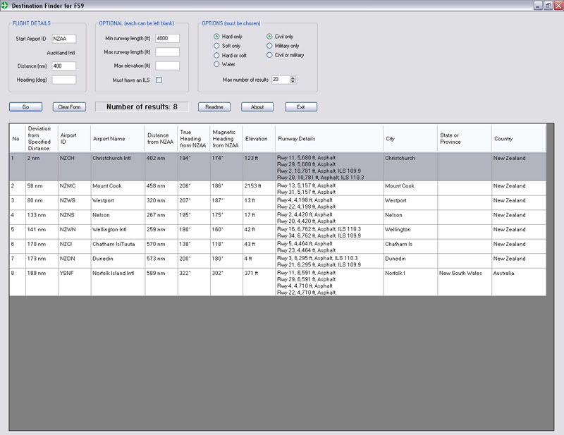
It's a great little program, and certainly helps with searching the thousands of airports out there.
"What do you do once you get to Easter Island?" NTGJ in French Polynesia is only 1402nm and has a 6500 ft runway - thanks to Destination Finder - and yes, it's the nearest airport :S
For example:
Search from Auckland. I want a flight distance of 400nm, and my aircraft needs a 4000ft runway. If you are heading a particular direction around the world, be sure to enter a heading. (I didn't on this search)
And here are the results, ranked by difference in miles from what was requested:
It's a great little program, and certainly helps with searching the thousands of airports out there.
"What do you do once you get to Easter Island?" NTGJ in French Polynesia is only 1402nm and has a 6500 ft runway - thanks to Destination Finder
- and yes, it's the nearest airport :SLast edited by AlisterC on Thu Nov 06, 2008 4:37 pm, edited 1 time in total.

-

AlisterC - NZFF Pro
- Joined: Thu Jul 20, 2006 11:13 am
- Posts: 2543
- Location: Nelson, NZ
![]() by PiperDriver » Thu Nov 06, 2008 6:17 pm
by PiperDriver » Thu Nov 06, 2008 6:17 pm
kiwibarguy wrote:QUOTE (kiwibarguy @ Nov 6 2008, 12:11 PM) <{POST_SNAPBACK}>Oh!! I forgot to mention G-HEVN as well as a master of tours, my bad!
As i posted above, check out the download for google earth, you can then see every possible choice available for airports, ndb's, vors etc, it is the best utility i've used this year.
I myself have been thinking which wa to go myself! Antartica, Easter island, or Alaska down back through the long way vis Japan, Indonesia...i suppose we are all limited by the craft we fly. I am glad i changed my 172 Skyhawk now. As i am am only using props maybe a Tupolev TU-95 is the answer for the great Pacific crossing!
Im not to sure which route im going to take yet. I have several possible routes which include the crossing the Atlantic and the pacific. I have to complete both of these legs as alot of GA aircraft are delivered via these routes.
Cant decide which aircraft though.
- PiperDriver
![]() by Chairman » Thu Nov 06, 2008 7:32 pm
by Chairman » Thu Nov 06, 2008 7:32 pm
Albatross wrote:QUOTE (Albatross @ Nov 6 2008, 05:32 PM) <{POST_SNAPBACK}>Another handy utility for planning world tours is a small program called "destination finder" (search that at avsim) and with it you can set a range of parameters to search, in order to find a suitable airport (without having to check in on each and every one)
"What do you do once you get to Easter Island?" NTGJ in French Polynesia is only 1402nm and has a 6500 ft runway - thanks to Destination Finder
Downloaded now. You Legend !!!
Soooo ...
NZAA - NCRG (Rarotonga) - 1627 nm
NCRG - NTGJ (Totegegie) - 1388 nm
NTJG - SCIP (Mataveri, Easter Island) - 1402 nm
SCIP - SCIR (Robinson Crusoe Island) - 1616 nm
SCIR - SBBU (Bauru,Brazil) - 1717 nm
and there you are in South America, and all of it well achievable in most twins.
Hmmmmm .......
GaryLast edited by Chairman on Thu Nov 06, 2008 7:58 pm, edited 1 time in total.The above post is in the public domain and is guaranteed by the manufacturer to contain no references to anything illegal or discussion of piracy, although this signature may contain traces of nuts.

- Chairman
- Sim-holic
- Joined: Wed Feb 13, 2008 8:07 pm
- Posts: 912
![]() by Chairman » Thu Nov 06, 2008 11:30 pm
by Chairman » Thu Nov 06, 2008 11:30 pm
The heck with that ! If I was going to fork out for a twin that was capable of flying back here it'd darn well fly back here !
At what size does seafreight become impractical ? You wouldn't want it shipped as deck cargo so presumably you could only do it with planes that could be disassembled enough to fit inside a container ?
Cheers
Gary
At what size does seafreight become impractical ? You wouldn't want it shipped as deck cargo so presumably you could only do it with planes that could be disassembled enough to fit inside a container ?
Cheers
Gary
The above post is in the public domain and is guaranteed by the manufacturer to contain no references to anything illegal or discussion of piracy, although this signature may contain traces of nuts.
- Chairman
- Sim-holic
- Joined: Wed Feb 13, 2008 8:07 pm
- Posts: 912
![]() by AlisterC » Fri Nov 07, 2008 6:48 am
by AlisterC » Fri Nov 07, 2008 6:48 am
Yeah, I was going for the small, disassemble type. I do know that when the Canterbury aeroclub got a new Piper Archer, they assembled it themselves when it arrived via shipping container. I'm pretty sure it would be a bad idea to strap it to the deck
I guess it's all up to the individual. I do remember that Pacific Aerospace aircraft went down in the Pacific on a delivery flight.. It's probably quite dangerous in a single GA
see here
I guess it's all up to the individual. I do remember that Pacific Aerospace aircraft went down in the Pacific on a delivery flight.. It's probably quite dangerous in a single GA
see here
Last edited by AlisterC on Fri Nov 07, 2008 6:48 am, edited 1 time in total.
-
AlisterC - NZFF Pro
- Joined: Thu Jul 20, 2006 11:13 am
- Posts: 2543
- Location: Nelson, NZ
![]() by deeknow » Fri Nov 07, 2008 7:35 am
by deeknow » Fri Nov 07, 2008 7:35 am
Albatross wrote:QUOTE (Albatross @ Nov 7 2008, 07:48 AM) <{POST_SNAPBACK}>I'm pretty sure it would be a bad idea to strap it to the deck
How about bolting some floats on and dropping into the ocean every now and then when you've spotted a friendly looking ship that might pump a little fuel down to you on the surface. Of course you'd prolly wanna convert the aircraft to dielsel engines
Seriously tho, has anyone here done a TEAL type round the world in a Short Solent or-what-have-you flying-boat?Last edited by deeknow on Fri Nov 07, 2008 7:36 am, edited 1 time in total.Deans repaints: http://www.deeknow.com/
X570 Mini-ITX m/b - Ryzen7 5700X3D (8c/16t) - RTX 2060-super - 32GB 3600MHz DDR4 - Win10 - P3Dv5.3
-
deeknow - NZFF Pro
- Joined: Tue Sep 18, 2007 10:15 pm
- Posts: 4484
- Location: NZHN
![]() by PiperDriver » Fri Nov 07, 2008 6:21 pm
by PiperDriver » Fri Nov 07, 2008 6:21 pm
deeknow wrote:QUOTE (deeknow @ Nov 7 2008, 08:35 AM) <{POST_SNAPBACK}>How about bolting some floats on and dropping into the ocean every now and then when you've spotted a friendly looking ship that might pump a little fuel down to you on the surface. Of course you'd prolly wanna convert the aircraft to dielsel engines
Seriously tho, has anyone here done a TEAL type round the world in a Short Solent or-what-have-you flying-boat?
Or perhaps a big airliner. lots of leg room but cannot land on water. Could use a flying boat that but would involve a lot of work to locate waterway with heaps of fuel for the radials
- PiperDriver
18 posts
• Page 1 of 1
Who is online
Users browsing this forum: No registered users and 13 guests