Page 1 of 1

PostPosted: Mon Jan 08, 2007 9:45 pm
by JonARNZ
Well Nik and I continued our trek, and what a flight it was. Absolutely terrible flying weather. Torrential rain and thunderstorms across our flightplan, but we start at Milford Sounds..

user posted image

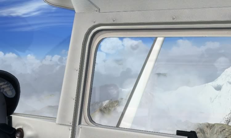
You know you're in trouble when the rains vertical and you cant see ahead...in the mountains...at low altitude...

user posted image

But we found the gaps, deftly dodging the dangerous dobstacles...

user posted image
user posted image

The turbulence was shocking, but beautifully generated in FSX (Pass me the barf bag please), especially in the VC. Finally the clouds part and the views are quite spectacular..

user posted image
user posted image

Heres a good one showing the bump mapping on the Goose..

user posted image

Time to begin our decent into Hokitika...

user posted image
user posted image

Finals and I had to crab my way to the threshold..

user posted image

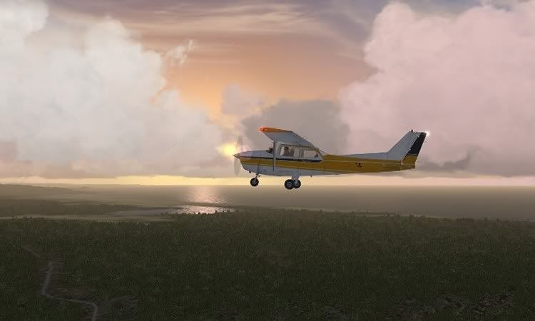
And then an hour later Nik Arrives, you see, he decided to fly a Cessna, give the man a medal given the conditions we faced. :clap:

user posted image

We were hoping to carry on to Greymouth and then Murchison (How many people get to fly into an airport that shares your name) but the weather precluded that. Tommorow with luck.

Tallyho chaps!

>nzflag<

PostPosted: Mon Jan 08, 2007 11:51 pm
by Zöltuger
JonARNZ wrote: How many people get to fly into an airport that shares your name

I've flown into NZZÖ many times :P
Love that goose, and the terrain looks stunning too!

PostPosted: Tue Jan 09, 2007 7:37 am
by Charl
Jon
What does bump-mapping do?
I"ve noticed in FSX, as the aircraft turns from the light into the shadow side, a shadow line creeps along its length - is that an effect of bump mapping?


Zöltuger wrote:
JonARNZ wrote: How many people get to fly into an airport that shares your name

I've flown into NZZÖ many times :P


Updated AFCAD file now available:

user posted image

PostPosted: Tue Jan 09, 2007 8:17 am
by Alex
Does Alexandra count for me? :P Nice pics there Jon. :D

Alex

PostPosted: Tue Jan 09, 2007 9:06 am
by JonARNZ
Bump mapping is exactly what it sounds like, it adds the rivet bumps, dents etc, anything that relates to a surface that you dont want sitting flat. The 'shadows' are something else again.

PostPosted: Tue Jan 09, 2007 9:06 am
by ZK-Brock
Great pics Jon, I've also been flying around MF recently on IVAO. Your scenery looks different to mine, are you using the RBE landclass + Mesh?

PostPosted: Tue Jan 09, 2007 9:40 am
by ardypilot
:lol: LOL at the ICAO's!

There is actually a strip called 'Forest Field' in Canterbury at S 43 23 09.0, E 172 21 38.0 and it's code is NZFF!

PostPosted: Tue Jan 09, 2007 10:10 am
by Alex
Yea, I thought thats why you called it NZFF, because it is sort of a pun! :lol:

Alex

PostPosted: Tue Jan 09, 2007 11:59 am
by Timmo
yeah- bump mapping is a way of making surfaces appear 3D without actually creating 3d surfaces (ie. if you had a create every rivet in 3d your system would be bogged down) so you just have another skin which is defined as 'bumps'.....bump maps are similar to terrain mesh in their principle: a raster image representing a 3d surface (its actually 2.5 D if you want to be pedantic)

PostPosted: Tue Jan 09, 2007 12:09 pm
by JonARNZ
Timmo wrote: yeah- bump mapping is a way of making surfaces appear 3D without actually creating 3d surfaces (ie. if you had a create every rivet in 3d your system would be bogged down) so you just have another skin which is defined as 'bumps'.....bump maps are similar to terrain mesh in their principle: a raster image representing a 3d surface (its actually 2.5 D if you want to be pedantic)

Hey were Flightsimmers, its out job to be pedantic! >buck<

PostPosted: Tue Jan 09, 2007 12:30 pm
by ZK-TJL
Hi Team.

Here's 2 of my screen shots from the NZMF - NZHK leg of our trip.

user posted image
user posted image

Cheers
Nik (ZK-TJL)

PostPosted: Tue Jan 09, 2007 12:39 pm
by ZK-Brock
Cool VC shot Nik! BTW, check your PMs