Oxford2Oxford


![]() by G-HEVN » Wed Jan 31, 2007 9:30 pm
by G-HEVN » Wed Jan 31, 2007 9:30 pm
It's an A330 according to the View ATC menu (personally, I wouldn't know from Adam -- they're all the same to me!  )
)
The AI is the freeware WoAI package downloaded from Avsim. Coverage is sparse compared to UT, which I had in FS9 - many of the airports I've visited on this trip have been completely devoid of AI - , but the planes look so much nicer IMHO. I use "GA Traffic" for non-airline stuff, which picks up on whatever I have installed and also the HTAI Cessnas (which I bought for the NZLAI stuff, although I've not yet installed that into FSX ). GAT does a nice job IMHO of balancing light vs coroprate traffic according to the size of the airport.
)The AI is the freeware WoAI package downloaded from Avsim. Coverage is sparse compared to UT, which I had in FS9 - many of the airports I've visited on this trip have been completely devoid of AI - , but the planes look so much nicer IMHO. I use "GA Traffic" for non-airline stuff, which picks up on whatever I have installed and also the HTAI Cessnas (which I bought for the NZLAI stuff, although I've not yet installed that into FSX ). GAT does a nice job IMHO of balancing light vs coroprate traffic according to the size of the airport.
- G-HEVN
![]() by G-HEVN » Thu Feb 01, 2007 9:08 am
by G-HEVN » Thu Feb 01, 2007 9:08 am
Leg 21: Colombo Bandarnaike Intl VCBI to Chennai Intl VOMM
Route: VCBI KK OM MMV VOMM 394nm, 2.5 hours (total: 9824nm 61.1 hours)
Woe! Woe! Thrice Woe! I've had my collar felt by the CAA (Campaign Against Aviation). Thanks to a 'technicality', I've had to have the trusty tour plane re-registered. So N15KP ia now... G-OXOX. Is it safer? No. Is it more reliable? No. Is it any different at all? No. Is it a pointless exercise in bureaucratic money wasting? Icouldn't possibly say!

So we leave Colombo in the re-stickered G-OXOX, and head back towards the Indian mainland.

Climbing over the Sri Lankan lowlands

And following the coast.

Some strange doubled up cloud formations!


Kankesanturai airbase at Jaffna, right on the northern tip of Sri Lanka. From here it looks like everyone's out!

Back over the mainland, and once again we see the far-reaching (according to FS!) influence of the Indian smog! Not sure I like how hard-edged FS makes it. Oh, and we've found the one major texture that RealAir mirrored! Grrr!

We're actually on right base for Chennai International. Can you spot the airport?

Lessons in aviation No 153: Don't land short when the exit is at the far end of the runway!

And here we are, the only ones on a deserted ramp. Still, nice terminal! Who's for a curry?
Route: VCBI KK OM MMV VOMM 394nm, 2.5 hours (total: 9824nm 61.1 hours)
Woe! Woe! Thrice Woe! I've had my collar felt by the CAA (Campaign Against Aviation). Thanks to a 'technicality', I've had to have the trusty tour plane re-registered. So N15KP ia now... G-OXOX. Is it safer? No. Is it more reliable? No. Is it any different at all? No. Is it a pointless exercise in bureaucratic money wasting? Icouldn't possibly say!
So we leave Colombo in the re-stickered G-OXOX, and head back towards the Indian mainland.
Climbing over the Sri Lankan lowlands
And following the coast.
Some strange doubled up cloud formations!
Kankesanturai airbase at Jaffna, right on the northern tip of Sri Lanka. From here it looks like everyone's out!
Back over the mainland, and once again we see the far-reaching (according to FS!) influence of the Indian smog! Not sure I like how hard-edged FS makes it. Oh, and we've found the one major texture that RealAir mirrored! Grrr!
We're actually on right base for Chennai International. Can you spot the airport?
Lessons in aviation No 153: Don't land short when the exit is at the far end of the runway!
And here we are, the only ones on a deserted ramp. Still, nice terminal! Who's for a curry?
- G-HEVN
![]() by ZK-Brock » Thu Feb 01, 2007 11:45 am
by ZK-Brock » Thu Feb 01, 2007 11:45 am
Lessons in aviation No 153: Don't land short when the exit is at the far end of the runway!
Heheh, reminds me of my last flight at NZNS. I came in at 60 knots but the winds kept changing so we had a slight tailwind. Anyway we came in a little high but at the right speed...and floated...and floated...and floated....and touched down right next to the turnoff to the Aero club hangar

- ZK-Brock
- NZFF Pro
- Joined: Sun Jul 23, 2006 3:35 pm
- Posts: 2035
![]() by G-HEVN » Fri Feb 02, 2007 9:51 am
by G-HEVN » Fri Feb 02, 2007 9:51 am
Leg 22: Chennai Intl VOMM to Bhubaneshwar VEBS
Route: VOMM BZ VVZ BBS VEBS, IFR. 649 nm, 3.8 hours (total 10473 nm, 64.9 hours)
From here, the original tour took a boat direct to Singapore. That's well beyond the range of our plane, and so we're going to have to go the long way round. I'd hoped to get to Calcutta, but even that is just too far away. And so we're off to Bhubaneshwar.

The ATIS informs us in no uncertain terms that visibility is only 2km. We're going to need to file IFR for this trip! As we taxi passt the exotic terninal building, the sun tries to punch a hole through the smog.

Lining up on runway 07: We can barely make out the end of the runway!

Very quickly we're above the smog layer, and it lies below us like a blanket as we climb out.

The Eastern Ghats rise above the mist in the distance.

But soon enough we're clear of it.

Let's make the most of the clear skies and good visibility...

... while we can...

... because it ain't gonna last. We're given vectors to the ILS, and eventually have to descend into the murk.

400ft AAL, and slightly high on the glideslope. We can see absolutely nothing!

Just seconds before decision height, we can make out the runway lights - it's always a satisfying feeling when those lights come into view!
Route: VOMM BZ VVZ BBS VEBS, IFR. 649 nm, 3.8 hours (total 10473 nm, 64.9 hours)
From here, the original tour took a boat direct to Singapore. That's well beyond the range of our plane, and so we're going to have to go the long way round. I'd hoped to get to Calcutta, but even that is just too far away. And so we're off to Bhubaneshwar.
The ATIS informs us in no uncertain terms that visibility is only 2km. We're going to need to file IFR for this trip! As we taxi passt the exotic terninal building, the sun tries to punch a hole through the smog.
Lining up on runway 07: We can barely make out the end of the runway!
Very quickly we're above the smog layer, and it lies below us like a blanket as we climb out.
The Eastern Ghats rise above the mist in the distance.
But soon enough we're clear of it.
Let's make the most of the clear skies and good visibility...
... while we can...
... because it ain't gonna last. We're given vectors to the ILS, and eventually have to descend into the murk.
400ft AAL, and slightly high on the glideslope. We can see absolutely nothing!
Just seconds before decision height, we can make out the runway lights - it's always a satisfying feeling when those lights come into view!
- G-HEVN
![]() by G-HEVN » Sat Feb 03, 2007 6:05 am
by G-HEVN » Sat Feb 03, 2007 6:05 am
Leg 23: Bhubaneshwar VEBS to Yangon Intl VYYY
Route: VEBS PTN VYYY 698 nm, 4.3 hours (total: 11171 nm, 69,2 hours)
On this leg, we're going to cut off the top of the Bay of Bengal, and route straight across the sea to Yangon (Rangoon). Obviously, for a long flight over water there are certain necessary preparations - liferaft, life jackets, water bottles (plus a couple of 'empties'!), GPS, and of course, a good book!

After yesterday's almost blind landing, it's refreshing to be able to see where we are!

Lining up on runway 14 We're fuelled to the max -- it's 3½ hours just over the water -- and with the extra survival kit, we're at max weight. Providing you hold a few things off the sales, that is!

Once above the haze, we discover some big bruiser clouds. These certainly weren't in the TAF!

Crossing the coast. Next land in something over three hours! Page 1. It was funny, Richard Sharpe thought, that there were no vultures in England. None that he'd seen, anyway...

Every degree of longitude we have to make a position report (hence the GPS), but we're quickly out of range of the land-based station, and so we're reliant on passing airliners to relay the reports for us. We don't have oxygen, so we're cruising at FL95, not that it makes much difference this far from land...

Eventually, we can make out the coast in the distance. Land Ho!!

We've been tracking the PTN VOR for more than an hour, and we fly straight over the top of it. No wonder I couldn't spot it out the window!

Approaching Yangon, and we're flying on fumes. They've just claimed to be IFR, which means they must be under that cloud over there.

IFR? Yeah, right! I can clearly see the runway from more than 3 miles away, and I'm out of options. "Golf Oscar XRay is declaring a fuel emergency..." "Um, okay, cleared to land." Thank you
A few moments later...
<splutter, cough>
"Yangon Ground, Anyone got a tow rope?"
Route: VEBS PTN VYYY 698 nm, 4.3 hours (total: 11171 nm, 69,2 hours)
On this leg, we're going to cut off the top of the Bay of Bengal, and route straight across the sea to Yangon (Rangoon). Obviously, for a long flight over water there are certain necessary preparations - liferaft, life jackets, water bottles (plus a couple of 'empties'!), GPS, and of course, a good book!
After yesterday's almost blind landing, it's refreshing to be able to see where we are!
Lining up on runway 14 We're fuelled to the max -- it's 3½ hours just over the water -- and with the extra survival kit, we're at max weight. Providing you hold a few things off the sales, that is!
Once above the haze, we discover some big bruiser clouds. These certainly weren't in the TAF!
Crossing the coast. Next land in something over three hours! Page 1. It was funny, Richard Sharpe thought, that there were no vultures in England. None that he'd seen, anyway...
Every degree of longitude we have to make a position report (hence the GPS), but we're quickly out of range of the land-based station, and so we're reliant on passing airliners to relay the reports for us. We don't have oxygen, so we're cruising at FL95, not that it makes much difference this far from land...
Eventually, we can make out the coast in the distance. Land Ho!!
We've been tracking the PTN VOR for more than an hour, and we fly straight over the top of it. No wonder I couldn't spot it out the window!
Approaching Yangon, and we're flying on fumes. They've just claimed to be IFR, which means they must be under that cloud over there.
IFR? Yeah, right! I can clearly see the runway from more than 3 miles away, and I'm out of options. "Golf Oscar XRay is declaring a fuel emergency..." "Um, okay, cleared to land." Thank you
A few moments later...
<splutter, cough>
"Yangon Ground, Anyone got a tow rope?"
- G-HEVN
![]() by G-HEVN » Sun Feb 04, 2007 10:58 am
by G-HEVN » Sun Feb 04, 2007 10:58 am
Leg 24: Yangon Intl VYYY to Bangkok Intl VTBD
Route: HGU MM KPS BKK 334nm, 2.6 hours (total: 11505nm 71.8 hours)

Just like the last few legs, we climb through a layer of smog, and basically sit above a haze layer for two and a half hours. Thrilling!

We're getting close to the top of our descent, and the sun starts to go down.

Giving an eerie pink glow through the haze. We're given joining instructions: Join left base for runway 3 left.

we're on base and number two to the airbus ahead on a straight in. Cleared to land!

Short final. Has the airbus vacated? I think he's vacated: I can't see him...

Oh craaaa*!!!


Phew!!

Oxford Xray please phone the tower on 555-3342 once you've parked up.
Ahem!
Route: HGU MM KPS BKK 334nm, 2.6 hours (total: 11505nm 71.8 hours)
Just like the last few legs, we climb through a layer of smog, and basically sit above a haze layer for two and a half hours. Thrilling!
We're getting close to the top of our descent, and the sun starts to go down.
Giving an eerie pink glow through the haze. We're given joining instructions: Join left base for runway 3 left.
we're on base and number two to the airbus ahead on a straight in. Cleared to land!
Short final. Has the airbus vacated? I think he's vacated: I can't see him...
Oh craaaa*!!!
Phew!!
Oxford Xray please phone the tower on 555-3342 once you've parked up.
Ahem!
- G-HEVN
![]() by ardypilot » Sun Feb 04, 2007 11:37 am
by ardypilot » Sun Feb 04, 2007 11:37 am
Wow you have a really good AI package, those models look much more detailed than the old UT stuff!
By the way, can you actually make mayday calls in FSX...?
"Golf Oscar XRay is declaring a fuel emergency"
By the way, can you actually make mayday calls in FSX...?
-

ardypilot - NZFF Pro
- Joined: Wed Apr 26, 2006 10:01 am
- Posts: 6802
- Location: Auckland
![]() by G-HEVN » Sun Feb 04, 2007 11:52 am
by G-HEVN » Sun Feb 04, 2007 11:52 am
It's World of AI, downloaded from AVSIM. It comes with an installer and separate airline packages, like PAI, but works both with FS9 and FSX. And it's free!  I've also now got VOZAI installed as well as NZLAP, but they won't appear till nearer the end of the tour.
No, you can't make mayday or pan calls in FSX, you have to just ignore the protestations of ATC, just as with FS9! (I believe the ATC system is pretty much unchanged).
I've also now got VOZAI installed as well as NZLAP, but they won't appear till nearer the end of the tour.No, you can't make mayday or pan calls in FSX, you have to just ignore the protestations of ATC, just as with FS9! (I believe the ATC system is pretty much unchanged).
- G-HEVN
![]() by G-HEVN » Mon Feb 05, 2007 10:02 am
by G-HEVN » Mon Feb 05, 2007 10:02 am
Leg 25: Bangkok Intl VTBD to Kuala Lumpur Simpang WMKF
Route: VTBD BKK HHN CPN STN KBI VAS VIH VBA WMKF 709nm, 4.5 hours (total: 12,214nm 76.3 hours)
We're going to make an early start today, so we can put as much distance between us and here before the tower guy gets back on shift. It was also suggested "somebody else drive", so today we have Copilot Bob in front, and I'm taking a back seat. Three rows back in fact. I wish to make that clear should anything... untoward... happen!

Loading up the last few bags. It's still quite dark, but the sun rises quickly in this part of the world.

Climbing out, and the approach controller gices us traffic in out 6 O'clock (do they think whe have eues in the backs of our heads?). Fortunately we spot it from the back of the plane. A 747, in what appears ro be a rather unusual attitude!

I wasn't quick enough to grab the dive -- this is pulling out!!! I'm glad it's not a passenger transport, but I'd also hate to have any cargo aboard! Shortly after this was taken, he dropped gear and landed as if nothing had happened!

Before long, the mist lifts and we have a splended view for an uneventful trip. Nearing KL, we're cleared into the circuit at Simpang. 22 is active, left-hand circuit.

Those of you that have met Bob, will know he can't tell left from right. So it won't surprise you that we end up on a right-hand downwind. I'm happily admiring the town as we turn base...

Hey, cool! It's just like an air race - they put out markers in the circuit!

Look at the people waving at us. I think they're waving!

I gotta say, this approach is waay better than Hong Kong!

Zoom Zoom!

I'm fuelling the plane. Bob's been asked up to the tower for a chat. They're probably going to congratulate him on a good approach!
Route: VTBD BKK HHN CPN STN KBI VAS VIH VBA WMKF 709nm, 4.5 hours (total: 12,214nm 76.3 hours)
We're going to make an early start today, so we can put as much distance between us and here before the tower guy gets back on shift. It was also suggested "somebody else drive", so today we have Copilot Bob in front, and I'm taking a back seat. Three rows back in fact. I wish to make that clear should anything... untoward... happen!
Loading up the last few bags. It's still quite dark, but the sun rises quickly in this part of the world.
Climbing out, and the approach controller gices us traffic in out 6 O'clock (do they think whe have eues in the backs of our heads?). Fortunately we spot it from the back of the plane. A 747, in what appears ro be a rather unusual attitude!
I wasn't quick enough to grab the dive -- this is pulling out!!! I'm glad it's not a passenger transport, but I'd also hate to have any cargo aboard! Shortly after this was taken, he dropped gear and landed as if nothing had happened!
Before long, the mist lifts and we have a splended view for an uneventful trip. Nearing KL, we're cleared into the circuit at Simpang. 22 is active, left-hand circuit.
Those of you that have met Bob, will know he can't tell left from right. So it won't surprise you that we end up on a right-hand downwind. I'm happily admiring the town as we turn base...
Hey, cool! It's just like an air race - they put out markers in the circuit!
Look at the people waving at us. I think they're waving!
I gotta say, this approach is waay better than Hong Kong!
Zoom Zoom!
I'm fuelling the plane. Bob's been asked up to the tower for a chat. They're probably going to congratulate him on a good approach!
- G-HEVN
![]() by ardypilot » Mon Feb 05, 2007 11:39 am
by ardypilot » Mon Feb 05, 2007 11:39 am
That was the most entertaining leg yet! I've been to KL in real life on the way to NZ from the UK (and stood on that bridge between the Petronas Towers- see pic below
 ), and when I saw you write Simpang, I thought you meant Seepang, in international airport, but I'm guessing by the close proximity of the CBD buildings in the last shot that there is a private GA field close by?
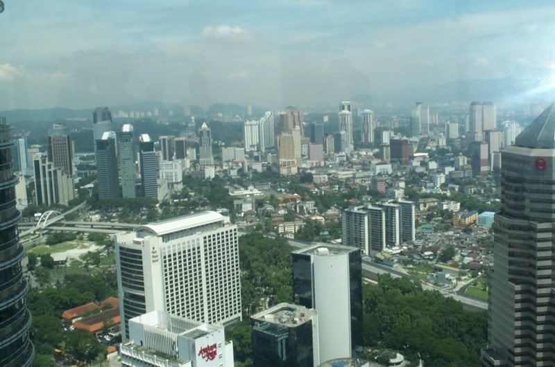
-
ardypilot - NZFF Pro
- Joined: Wed Apr 26, 2006 10:01 am
- Posts: 6802
- Location: Auckland
![]() by G-HEVN » Mon Feb 05, 2007 12:40 pm
by G-HEVN » Mon Feb 05, 2007 12:40 pm
Simpang was originally the international airport, but it's now an Air Force Base, although it does have a civillian flying club (according to google!). The Petronas Twin Towers pretty much are on right base for runway 22 (using a 'student sized' slightly wide circuit). Pretty close anyhow. It's in your 8 o'clock on your photo.
Its Icao is WMKF, so it's easy enough to find in FS.
Its Icao is WMKF, so it's easy enough to find in FS.
- G-HEVN

![]() by G-HEVN » Tue Feb 06, 2007 10:39 am
by G-HEVN » Tue Feb 06, 2007 10:39 am
Leg 26: Kuala Lumpur Simpang WMKF to Singapore Changi WSSS
Route: WKMF VMK PLA WSSS 180nm, 1.4 hours (total 12,394nm, 77.7 hours)
Today's tactic is basically one of denial: It couldn't possibly have been us, we didn't fly any plane at all yesterday, nosir. It must be working, because today we've managed to blag our way into a DC3 going down to Changi.

Lined up on 22, ready to go. The Petronas Twin Towers in the background look none nthe worse for their experience - I thbink we got away with it. Erm, if it was us, which it wasn't, of course!

Up, Up, and Away!

Descending into Singapore. We're cleared to join right base for runway 20 Right

We're now established on base, and I guess we're going to be in for some fun - see those two dots on long final?

Turning final. We're cleared, and the other guy is number two

Well, like he paid attention in 'Airmanship for Dummies' class!

Just to make sure we get the worst possible effect, he's now going around! Somebody get his number -- if you can -- it's gonna get real bumpy from his wake!

Our not so little plane still looks tiny against these big fellows!

Since we have a little time to spare, I thought I'd recap on our progress to date. You can see the original Morris Oxford journey in cyan. Where they had the car shipped instead of driving is shown in dark blue. Our route is shown in red. The inset shows our route for this leg.
Route: WKMF VMK PLA WSSS 180nm, 1.4 hours (total 12,394nm, 77.7 hours)
Today's tactic is basically one of denial: It couldn't possibly have been us, we didn't fly any plane at all yesterday, nosir. It must be working, because today we've managed to blag our way into a DC3 going down to Changi.
Lined up on 22, ready to go. The Petronas Twin Towers in the background look none nthe worse for their experience - I thbink we got away with it. Erm, if it was us, which it wasn't, of course!
Up, Up, and Away!
Descending into Singapore. We're cleared to join right base for runway 20 Right
We're now established on base, and I guess we're going to be in for some fun - see those two dots on long final?
Turning final. We're cleared, and the other guy is number two
Well, like he paid attention in 'Airmanship for Dummies' class!
Just to make sure we get the worst possible effect, he's now going around! Somebody get his number -- if you can -- it's gonna get real bumpy from his wake!
Our not so little plane still looks tiny against these big fellows!
Since we have a little time to spare, I thought I'd recap on our progress to date. You can see the original Morris Oxford journey in cyan. Where they had the car shipped instead of driving is shown in dark blue. Our route is shown in red. The inset shows our route for this leg.
- G-HEVN

![]() by ardypilot » Tue Feb 06, 2007 4:38 pm
by ardypilot » Tue Feb 06, 2007 4:38 pm
Another entertaining leg- and I know the feeling of dam AI fouling up your touring experience. See this thread for an example: http://z11.invisionfree.com/nzff/index. ... topic=1517
To fix this 'on finals' problem, Dorain recomended me a tool called 'AI Smooth' which can be found as freeware here: http://www.sg-flightware.de/ (not sure if it is FSX compatable, but worth a shot)
To fix this 'on finals' problem, Dorain recomended me a tool called 'AI Smooth' which can be found as freeware here: http://www.sg-flightware.de/ (not sure if it is FSX compatable, but worth a shot)
-
ardypilot - NZFF Pro
- Joined: Wed Apr 26, 2006 10:01 am
- Posts: 6802
- Location: Auckland


Who is online
Users browsing this forum: No registered users and 9 guests