Page 1 of 1

PostPosted: Thu Dec 13, 2007 5:27 pm
by Kelburn
I started the AFCAD today and tomorrow I shall start putting in the buildings.


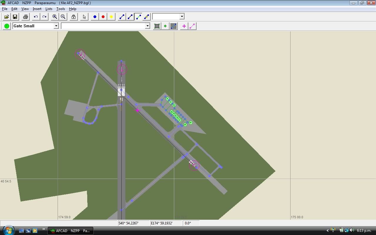
(I used AFCAD grass as the default FS didn't cover the whole afcad.)

Based on real experiences and google earth

I need to make an exclude (any help on autogen excludes?)

Also it shall hopefully be RealNZ ready after 24th (xmas present hopefully)? - this one won't have the AFCAD grass

PostPosted: Thu Dec 13, 2007 5:38 pm
by Dan
Great looking scenery. Be sure to put oodles of GA parking spaces to keep up with GNZLAP ;)

An exclude file can be created with FSSC. FSSC is an older programme that doesn't use FSUIPC, which is annoying at times. The file it creates tends to wipe out everything in lower layers, but that's fine if the AFCAD file is in the same scenery directory as the exclude file.

PostPosted: Thu Dec 13, 2007 6:12 pm
by NZ255
Nice Kelburn :clap:

Looks just like the one I made (accurate!), but never uploaded because I couldn't seem to get rid of the damn fuel pumps in the middle of the taxi way, and didn't want to move around it because then it wouldn't be accurate.

Looking forward to it being uploaded!

(BTW there are also grass runways for the gliding club and grass taxiways that are used to taxifrom the main parking area, (parrallel with 11 and 29) to runway 16. See here)

PostPosted: Thu Dec 13, 2007 6:35 pm
by ZK-Brock
Kelburn, what happens if you delete the afcad grass? What would it look like?

PostPosted: Thu Dec 13, 2007 6:41 pm
by Kelburn
Dan, I currently use FSSC anyway so thanks.

NZ255 thanks for reminding me as I forgot (on Sunday there was a sign saying that that runway was closed I think)

ZK-Brock, it looks really repetitive and umm. . . it didn't look quite right.

PostPosted: Thu Dec 13, 2007 6:51 pm
by NZ255
Kelburn wrote:
QUOTE (Kelburn @ Dec 18 2007, 06:41 AM) <{POST_SNAPBACK}>
NZ255 thanks for reminding me as I forgot (on Sunday there was a sign saying that that runway was closed I think)


Closed?, what, 11/29?

PostPosted: Thu Dec 13, 2007 6:56 pm
by greaneyr
That's a great-looking AFCAD! I like how you've added in parts of the link taxiway (used to be a runway I think?) west of the main runway. It's not shown on the AIP charts, so it never seems to get noticed but indeed on Google Earth shots it is still there.

Richard

PostPosted: Thu Dec 13, 2007 7:55 pm
by Kelburn
QUOTE
Closed?, what, 11/29?[/quote]

Bad weather (wet e.g. not allowed to use like wet cricket grounds)

PostPosted: Fri Dec 14, 2007 7:01 am
by Kelburn
I'll just say that at the moment it will be a nova texture version but when I next go up there I'll hopefully take some photos of the aeroclub