I just thought id start this to let people know how things are going with my little 'Bay of Plenty Islands' Project.
So far most of it has been experimentation and learning the SDK.....but i think im getting somewhere.
The scenery will cover the main off shore islands in the Bay of Plenty. Namely: White, Whale (Motuhora) and Motiti....possibley Mayor island as well
Issues so far have been-
If I simply clip the aerial image to the actual island shoreline, the default shoreline shows through = Bad
If i use 'nullvalue' in the resample, it doesnt ignore the watermask as well which leaves a black area underneath (instead of water) = Bad
I thnk ive got around that by specifying a blendmask image as well...
Ill also need to redo the mesh for Motiti since the default placement is wrong (according to our aerial photo placement....which may also be wrong...we dont have any GPS data out there to verify which is correct)
Ill keep everyone posted....what looked like simple test project is getting more and more complex
Bay of Plenty Islands: In Progress
19 posts
• Page 1 of 1
![]() by Timmo » Thu Jan 18, 2007 8:57 am
by Timmo » Thu Jan 18, 2007 8:57 am
Ok good news on two fronts 
1) I sussed out my workflow for creating scenery- I use three images: The actual image of the Island, A land/water mask image generated from a digitised polygon shoreline (Ive had to digitise these myself to exactly match the photo) and a Blend mask image created from generating a new buffer shapefile based on the shoreline dataset with 15 concenctric buffers at about 10m each- a greyscale colour ramp is then applied to these buffer rings creating a nice blend effect :0) Clever eh!
Ive still yet to apply autogen and library objects to the islands though. Ive decided to include Mayor island as well
2) My boss has agreed to let me release the data (after checking the license agreement...he also wants a test flight too haha)....
Im also working on a 'Towns of the Bay of Plenty' photo real dataset-
My reasoning is Towns are major VFR landmarks but the landclass misses out many small towns or if they are included, the default textures arent realistic/ representitive of NZ towns. On the other hand, providing large areas of photo real scenery is a lot of work, file sizes are large and large areas of bush and pasture can/are fairly well represented by the landclass + generic texture method.....So, the compromise is to just release the 'Urban areas' of small towns as photo real textures: Small files sizes, less work...more bang for your buck
- Timmo
- NZFF Pro
- Topic author
- Joined: Wed Oct 25, 2006 6:28 pm
- Posts: 2056
- Location: Tauranga
 to bad i was hoping of something up there too {my bad never mind } great work dude
![]() by Snowman » Thu Jan 18, 2007 9:19 am
by Snowman » Thu Jan 18, 2007 9:19 am
I will be looking forward very much to the completion of the "Towns of the Bay of Plenty" project.
I live in the Bay of Plenty, and would Love to see a few more recognisable towns in the area while flying from Robin's RealNZ Tauranga.
GO the Bay !!
Lawrie.
I live in the Bay of Plenty, and would Love to see a few more recognisable towns in the area while flying from Robin's RealNZ Tauranga.
GO the Bay !!
Lawrie.
Last edited by Snowman on Thu Jan 18, 2007 9:19 am, edited 1 time in total.


-

Snowman - NZFF Pro
- Joined: Wed Jul 26, 2006 3:52 pm
- Posts: 2427
- Location: Tauranga, NZ.
![]() by Timmo » Thu Jan 18, 2007 10:14 am
by Timmo » Thu Jan 18, 2007 10:14 am
hmm good point- Can you post a top down image and/or the extents of the photoreal scenery that comes with RealNZ Tauranga- Ill need to make sure i dont over lap with that data
Cheers
Cheers
- Timmo
- NZFF Pro
- Topic author
- Joined: Wed Oct 25, 2006 6:28 pm
- Posts: 2056
- Location: Tauranga

![]() by Timmo » Fri Jan 26, 2007 6:36 am
by Timmo » Fri Jan 26, 2007 6:36 am
I just completed Mayor island....its a pretty cool island actually. now ive just got to put the autogen on. A Libray object for the DOC hut on Whale, steam on white, helipad and antenna on whale, and realign Motiti
- Timmo
- NZFF Pro
- Topic author
- Joined: Wed Oct 25, 2006 6:28 pm
- Posts: 2056
- Location: Tauranga
![]() by Snowman » Fri Jan 26, 2007 3:03 pm
by Snowman » Fri Jan 26, 2007 3:03 pm
Timmo wrote: hmm good point- Can you post a top down image and/or the extents of the photoreal scenery that comes with RealNZ Tauranga- Ill need to make sure i dont over lap with that data
Cheers
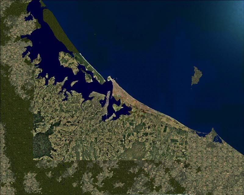
Top down look onto the area covered by Robin's Real NZ Tauranga.
COvers quite a large area, and the airport is incredibly well detailed. None of the outlying towns are modeled, nor are there any landmark downtown buildings like the Westpac tower, or other well known landmmarks such as the Baypark Raceway, Bayfair Shopping Centre etc.
There is a representation of the twin towers at the base of the Mount, and the Port area is quite nicely modeled as well.
Lawrie.
-
Snowman - NZFF Pro
- Joined: Wed Jul 26, 2006 3:52 pm
- Posts: 2427
- Location: Tauranga, NZ.
![]() by Timmo » Fri Jan 26, 2007 5:21 pm
by Timmo » Fri Jan 26, 2007 5:21 pm
OK- Have successfully re-aligned Motiti Island...what a mission! Im not sure what is correct, our aerial photos or the default data but it took a long time to correct the misalignment between the two..
At first I thought about just replacing the terrain mesh...but this wasnt possible, so ended up resampling everything and specifying the X, Y coordinates and cell size....trial and error until it lined up (probably compiled everything 20 times!)....
But its done...
As for Te Puke, its planned to be part of my 'BOP Towns project' but im kinda waiting for Christian to release his FSX landclass update...i need to see what effect this will have first (as ill likely have to make up some small landclass tweaks to avoid the land class derived urban textures from 'leaking' over the edge of my photo real textures)
- Timmo
- NZFF Pro
- Topic author
- Joined: Wed Oct 25, 2006 6:28 pm
- Posts: 2056
- Location: Tauranga
![]() by Grumble » Wed Feb 14, 2007 3:40 pm
by Grumble » Wed Feb 14, 2007 3:40 pm
Timmo wrote: OK- Have successfully re-aligned Motiti Island...what a mission! Im not sure what is correct, our aerial photos or the default data but it took a long time to correct the misalignment between the two..
At first I thought about just replacing the terrain mesh...but this wasnt possible, so ended up resampling everything and specifying the X, Y coordinates and cell size....trial and error until it lined up (probably compiled everything 20 times!)....
But its done...
As for Te Puke, its planned to be part of my 'BOP Towns project' but im kinda waiting for Christian to release his FSX landclass update...i need to see what effect this will have first (as ill likely have to make up some small landclass tweaks to avoid the land class derived urban textures from 'leaking' over the edge of my photo real textures)
Hey there Timmo... any progress? (can you tell I'm dying here waiting for it!

- Grumble
- Forum Addict
- Joined: Tue Jan 23, 2007 3:15 pm
- Posts: 163
![]() by Timmo » Tue Feb 20, 2007 1:12 pm
by Timmo » Tue Feb 20, 2007 1:12 pm
Yeah ive just been doing the auto gen for the textures....just have White Island to go as well as a few libary objects for Whale and possibly writing the XML for the airstrip at Motiti...
Then there are a few other issues to sort such as testing...would hope that it isnt too much longer
Then there are a few other issues to sort such as testing...would hope that it isnt too much longer
- Timmo
- NZFF Pro
- Topic author
- Joined: Wed Oct 25, 2006 6:28 pm
- Posts: 2056
- Location: Tauranga
![]() by Timmo » Wed Feb 21, 2007 6:54 am
by Timmo » Wed Feb 21, 2007 6:54 am
here are a couple....it would be more but I have to leave for work. Added the autogen to White island last night and had a quick go at adding steam.
So all the autogen for the islands is done!
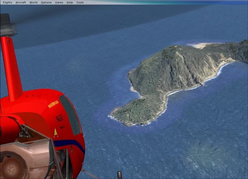
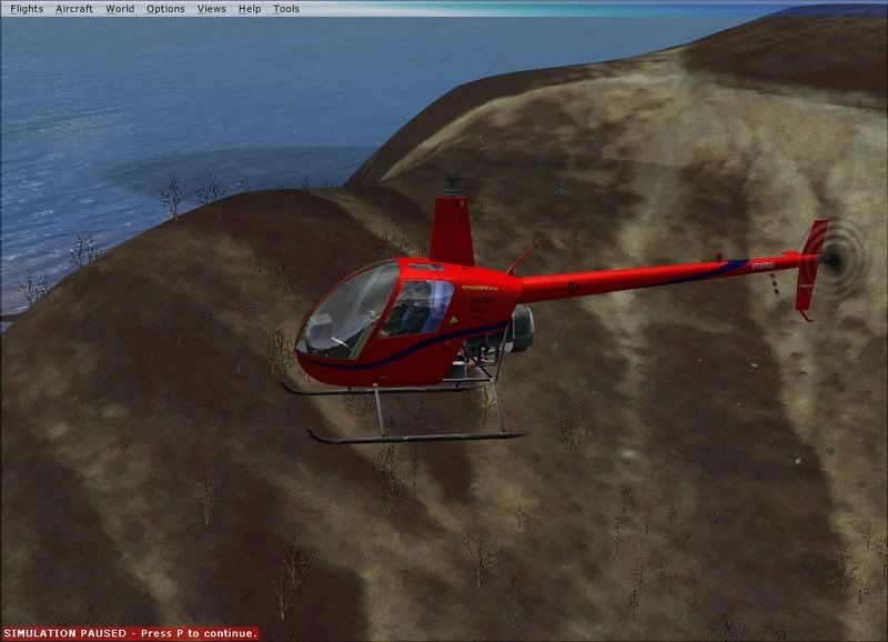
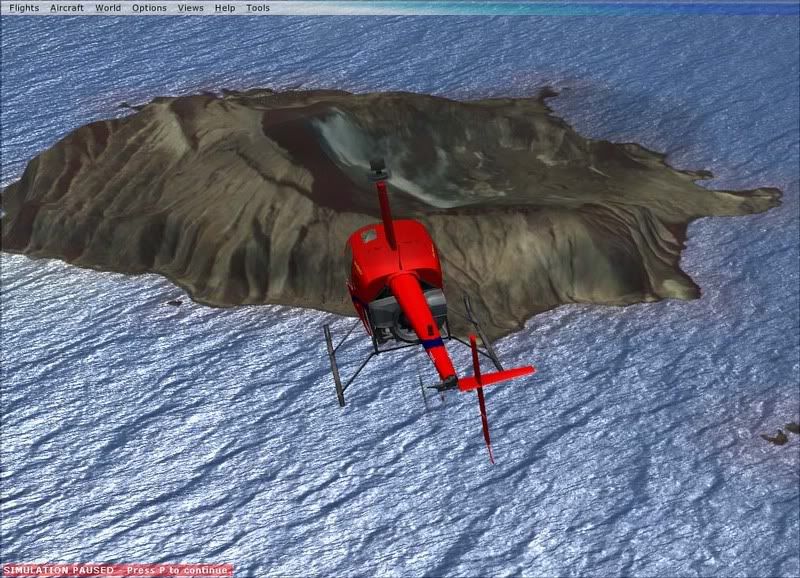
White island has quite low resolution since we dont have any orthophotos for it....its just a scanned contact print.
Cheers
So all the autogen for the islands is done!
White island has quite low resolution since we dont have any orthophotos for it....its just a scanned contact print.
Cheers
- Timmo
- NZFF Pro
- Topic author
- Joined: Wed Oct 25, 2006 6:28 pm
- Posts: 2056
- Location: Tauranga


19 posts
• Page 1 of 1
Who is online
Users browsing this forum: No registered users and 22 guests