Hey Guys I Am Desperate for some photo real textures for Napier every where else has photo real popping up except for Napier, why is this? And is there any photo real for Napier out there??


Nzeddy wrote:QUOTE (Nzeddy @ Nov 12 2010, 06:30 PM) <{POST_SNAPBACK}>Been working with this for at least 3 or 5 days. Still a WIP.
Im keen to do the Napier photoreal.


Eddy You Are My Idol, That Looks Awsome
 Know what I mean? Hence me not being in an overly large rush to have photo-real, knowing that much of the free stuff is just too old.
Jamessx wrote:QUOTE (Jamessx @ Nov 13 2010, 08:46 AM) <{POST_SNAPBACK}>Eddy You Are My Idol, That Looks Awsome
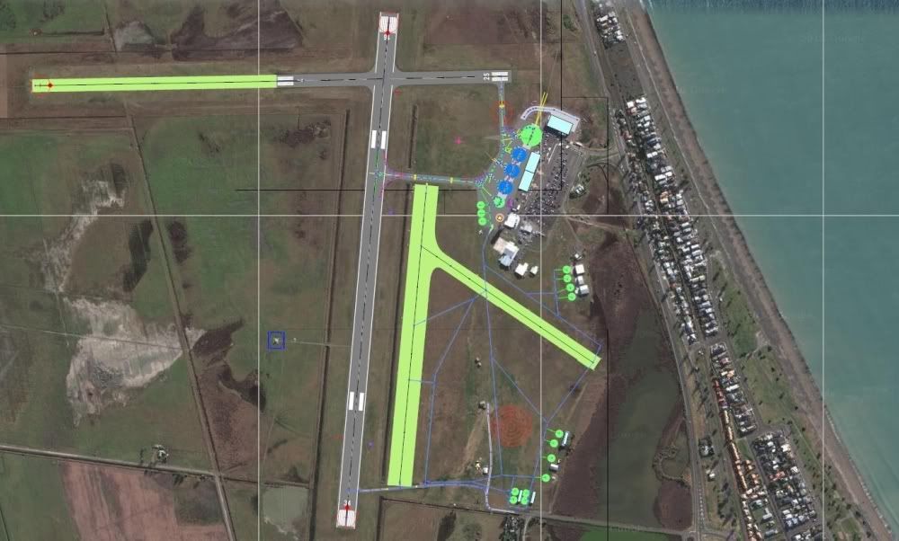
It's not what you think it is but the photoreal is just a background image to help me to design the AFCAD. So there won't be any high res image in my Napier AFCAD.IslandBoy77 wrote:QUOTE (IslandBoy77 @ Nov 13 2010, 10:53 AM) <{POST_SNAPBACK}>Eddy: what source imagery are you using, and how old is it?
I got the image from SBuilderX using Google Maps so I have no idea how old it is.
EDIT:
Yay.
Posted: Sat Nov 13, 2010 11:08 am
Have a look here Napier 2009 10cm per pixel
It's for sale at $0.56 to $6.40 per hectare so could end up being an expensive venture. Would be happy to lay it down if it's purchased.
NickNzeddy wrote:QUOTE (Nzeddy @ Nov 13 2010, 11:35 AM) <{POST_SNAPBACK}>What software did you use to lay down the photoreal Eddy?
NZ255 wrote:QUOTE (NZ255 @ Nov 13 2010, 12:08 PM) <{POST_SNAPBACK}>What software did you use to lay down the photoreal Eddy?
FWTools.
Looked at the Napier 2009 link and croped the image surrounding the airport. Came up to about $920. No thanks.
Yep, the purchase-able stuff is expensive, alright. I spoke to NZAM about their stuff - got up in to the thousands of $ for just the immediate Napier city / airport area. They weren't interested in any deals for free, give-away sim work...Nzeddy wrote:QUOTE (Nzeddy @ Nov 13 2010, 11:35 AM) <{POST_SNAPBACK}>I got the image from SBuilderX using Google Maps so I have no idea how old it is.
According to Google, that particular tile is Jan 2005. The one south of it is July 2009.
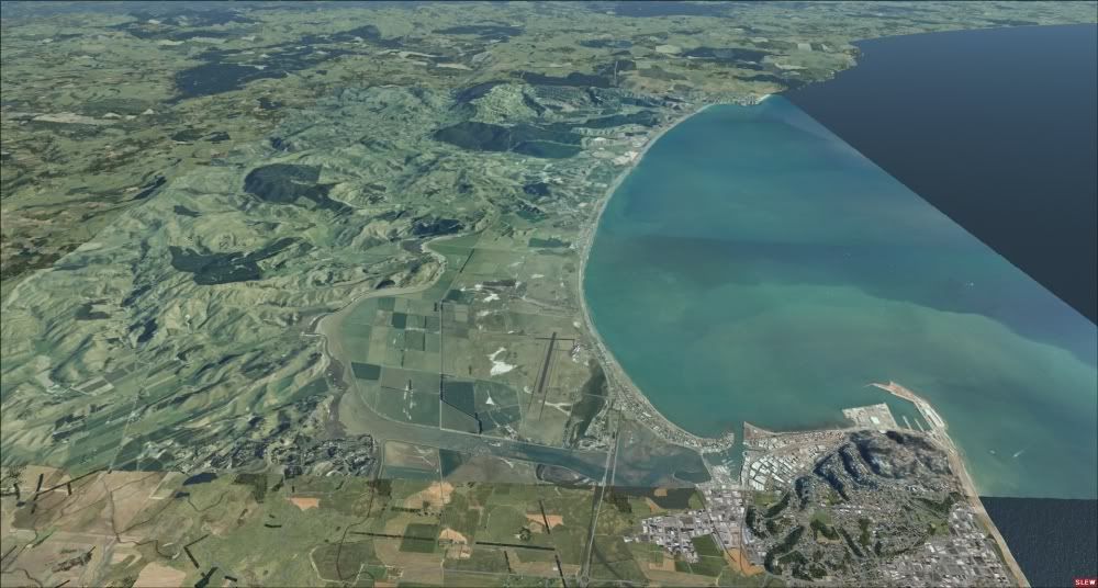
Ok, I'm planning to make this Napier scenery a free FSX project.
This will include photoreal coverage from Napier to Hastings, autogen and a highly detailed AFCAD with all the fancy taxilines etc.
If anyone can help that will be very great.
hopefully there is a cheap source you can use, cause you cant use google images.
Nzeddy wrote:QUOTE (Nzeddy @ Nov 13 2010, 01:53 PM) <{POST_SNAPBACK}>Ok, I'm planning to make this Napier scenery a free FSX project.
This will include photoreal coverage from Napier to Hastings, autogen and a highly detailed AFCAD with all the fancy taxilines etc.
If anyone can help that will be very great.
Eddy That Would be excellent I can give you a hand if you need but im a noob at this sort of stuff
kcgb wrote:QUOTE (kcgb @ Nov 13 2010, 02:15 PM) <{POST_SNAPBACK}>hopefully there is a cheap source you can use, cause you cant use google images.
It's not what you think it is but the photoreal is just a background image (google image) to help me to design the AFCAD. So there won't be any Google high res imagery in my Napier AFCAD.Jamessx wrote:QUOTE (Jamessx @ Nov 13 2010, 03:22 PM) <{POST_SNAPBACK}>Eddy That Would be excellent I can give you a hand if you need but im a noob at this sort of stuff
Maybe some photos of the main airport buildings eg terminal, tower, hangers etc.
Eddy- Have a look on Koordinates.com as I think Napier is covered with a free LINZ aerial (slightly lower res but still fine for FSX)
Cheers
Timmo wrote:QUOTE (Timmo @ Nov 13 2010, 04:18 PM) <{POST_SNAPBACK}>Eddy- Have a look on Koordinates.com as I think Napier is covered with a free LINZ aerial (slightly lower res but still fine for FSX)
Thanks for that but I'm already using LINZ aerial for big photoreal coverage.
http://www.linz.govt.nz/topography/aerial-...pv21/index.aspx
http://www.linz.govt.nz/topography/aerial-...bj39/index.aspx
Im using the Google image to help me with the AFCAD.
Nzeddy wrote:QUOTE (Nzeddy @ Nov 13 2010, 03:52 PM) <{POST_SNAPBACK}>It's not what you think it is but the photoreal is just a background image (google image) to help me to design the AFCAD. So there won't be any Google high res imagery in my Napier AFCAD.
Maybe some photos of the main airport buildings eg terminal, tower, hangers etc.
Sure Thing
My undertstanding is that the HB Scenery on Google Maps is from around 2005.
Somehow, Microsoft Bing has been able to get their hands on the latest sets, especially for Napier City. So, these are about a year old.