NZTE - Te Kowhai

An area to discuss scenery addons for virtual NZ

Postby mattyHamNZ » Fri Feb 12, 2010 7:00 pm

Hi Guys,

It was great to meet a few of you (briefly mind you) at Tauranga the other day. Was flippen hot aye!!
I mentioned then, and have posted before on the subject... I have my first scenery design attempt pretty much finished and would like to release it as freeware for anyone who may be interested.

But.......I have some issues to sort out first

Firstly, the whole thing is sitting on a blend of my photography and imagery sorced from Google which creates a bit of a copywrite issue???

Secondly, the surrounding area that it sits on is all Google sourced imagery which is not blended.

Thirdly, the scenery as a whole, is only about 90% there as I haven't figured out a few minor issues and have been too busy with work to research it.


Any suggestion what I could do to get it out quickly?? unsure.gif


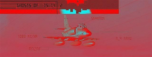
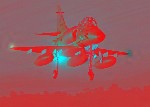
Here's some screenshots...


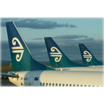
And here is the real thing...
Last edited by mattyHamNZ on Fri Feb 12, 2010 7:03 pm, edited 1 time in total.
mattyHamNZ
Member
 
Topic author
Joined: Fri Mar 20, 2009 4:28 pm
Posts: 48
Location: Hamilton

Postby NZ255 » Fri Feb 12, 2010 11:17 pm

wow that's nice. Had you had any previous experience or was this your first?
Nick
User avatar
NZ255
NZFF Pro
 
Joined: Wed Jun 20, 2007 12:57 pm
Posts: 2475

Postby mattyHamNZ » Sat Feb 13, 2010 7:23 am

NZ255 wrote:
QUOTE (NZ255 @ Feb 13 2010, 12:17 AM) <{POST_SNAPBACK}>
wow that's nice. Had you had any previous experience or was this your first?


That was my first.

I downloaded Gmax mid/late last year and started reading up on scenery design. Robin Corns tutorials were a real help here!
mattyHamNZ
Member
 
Topic author
Joined: Fri Mar 20, 2009 4:28 pm
Posts: 48
Location: Hamilton

Postby redkiwi » Sat Feb 13, 2010 9:23 am

You could try going on GoogleEarth and having a look at who owns the copyright to the photos. You may be able to get copies for cheap/free from the local council or whoever it is that holds the rights.
redkiwi
Forum Addict
 
Joined: Mon Jan 14, 2008 4:11 pm
Posts: 193

Postby Ian Warren » Sat Feb 13, 2010 9:44 am

Done an awesome Job there Matt , RedKiwi may have a point , maybe an idea to show exactly what your going to use it for to the people concern remember to mention it free for all users from every part off the world ... myself , have my fingers crossed ! .
Image
User avatar
Ian Warren
NZFF Pro
 
Joined: Fri May 05, 2006 5:23 pm
Posts: 41187
Location: AREA 51

Postby JohnM » Sat Feb 13, 2010 10:49 am

Fantastic effort mate should be proud,well done........ smile.gif
JohnM
Member
 
Joined: Fri Feb 12, 2010 11:19 am
Posts: 34
Location: Sydney,Australia

Postby Transit » Sat Feb 13, 2010 10:55 am

Well that's done it !
I will really have to get my stick back from my Mate smile.gif
Fantastic work
Pete
Transit
Member
 
Joined: Tue Feb 09, 2010 7:46 pm
Posts: 31

Postby mattyHamNZ » Sat Feb 13, 2010 4:07 pm

Thanks for the comments guys! I will try out the Waikato council but I wouldn't hold my breath. blink.gif
mattyHamNZ
Member
 
Topic author
Joined: Fri Mar 20, 2009 4:28 pm
Posts: 48
Location: Hamilton

Postby NZ255 » Sat Feb 13, 2010 7:21 pm

Just make sure they know it's for non-commercial use
Nick
User avatar
NZ255
NZFF Pro
 
Joined: Wed Jun 20, 2007 12:57 pm
Posts: 2475

Postby mattyHamNZ » Sun Feb 14, 2010 8:24 am

Has anyone else gone down the road of investigating the use of Google imagery as freeware and succeeded? I wonder if there would be a way to get a free pass for such a thing as a group for all NZ imagery? If we took them to task as a group who is not out to make a profit, then we could work together as a group to build a photoreal NZ?? Just thinking aloud? dry.gif
Wouldn't that be a fantastic freeware package to have as a building platform for any future development in FSX? Payware or freeware as it would be independant.

Your thoughts??
mattyHamNZ
Member
 
Topic author
Joined: Fri Mar 20, 2009 4:28 pm
Posts: 48
Location: Hamilton

Postby ZK-MAT » Sun Feb 14, 2010 9:55 am

I may be wrong, but I recall Robin Corn commenting on this aspect of Google images a while back. Google itself doesn't own the scenery, you simply use their software to view it. You'd have to obtain the rights to use the individual scenery tiles form the owners of the scenery - so in essence you'd have to approach quite a few organisations. Not that you couldn't do that!
User avatar
ZK-MAT
Senior Member
 
Joined: Sun Apr 30, 2006 11:41 pm
Posts: 1690
Location: Papamoa

Postby mattyHamNZ » Sun Feb 14, 2010 10:31 am

Here's a quote from google.... "We're flattered to hear that you're further incorporating Google Earth into your online world. You can personally use an image from the application (for example on your website, on a blog or in a word document) as long as you preserve the copyrights and attributions including the Google logo attribution. However, you cannot sell these to others, provide them as part of a service, or use them in a commercial product such as a book or TV show without first getting a rights clearance from Google.

If you require these commercial rights, please visit Google's permissions guidelines. You can then submit your application through our online request form.

Please note that we'll only be able to respond to permission requests submitted through the above form."


What does this mean??

I think it would allow the use of any of their imagery so long as it is not part of any commercial product/service?? Sounds like a freeware project to me?? smile.gif
Last edited by mattyHamNZ on Sun Feb 14, 2010 10:40 am, edited 1 time in total.
mattyHamNZ
Member
 
Topic author
Joined: Fri Mar 20, 2009 4:28 pm
Posts: 48
Location: Hamilton

Postby NZ255 » Sun Feb 14, 2010 1:24 pm

I would say so
Nick
User avatar
NZ255
NZFF Pro
 
Joined: Wed Jun 20, 2007 12:57 pm
Posts: 2475

Postby mattyHamNZ » Sun Feb 14, 2010 2:09 pm

So I could in theory make my scenery available for free and acknolodge Google as the imagery source... Hmmmmm dry.gif

What does everyone think of that? How about the whole country done in parts? Recolour all the imagery to create a good blend etc??
mattyHamNZ
Member
 
Topic author
Joined: Fri Mar 20, 2009 4:28 pm
Posts: 48
Location: Hamilton

Postby ZK-MAT » Sun Feb 14, 2010 2:09 pm

... as long as you have the Google Logo or credit to the picture supplier in the senery? Maybe design billboards around the secenery with credits on them lol.
User avatar
ZK-MAT
Senior Member
 
Joined: Sun Apr 30, 2006 11:41 pm
Posts: 1690
Location: Papamoa

Postby Kahu » Sun Feb 14, 2010 2:39 pm

Go for it!!!! Australia.gif You Can Do It!!!
Image
User avatar
Kahu
Sim-holic
 
Joined: Sat May 05, 2007 3:59 pm
Posts: 578
Location: Tauranga

Postby mattyHamNZ » Sun Feb 14, 2010 3:06 pm

To give you an idea of what I have so far.... its covering the greater waikato region from Raglan to Karapero(East to west) and Ngaruawahia to Te awamutu (North to South) at around 1m per pixel resolution and the Hamilton airport at around 30cm or better res? Not much in the way of autogen as I have been too lazy.

The file size is the problem at around 4-5gig? Who likes to use torrents? unsure.gif

Anyways, the whole area needs a touch up before I would let it go out. ??Thoughts??
Last edited by mattyHamNZ on Sun Feb 14, 2010 3:10 pm, edited 1 time in total.
mattyHamNZ
Member
 
Topic author
Joined: Fri Mar 20, 2009 4:28 pm
Posts: 48
Location: Hamilton

Postby Ian Warren » Sun Feb 14, 2010 3:45 pm

I wonder , currently AGNING the area wonder how both could mesh together , i check how close 'Mikes' could work with your effort .
Image
User avatar
Ian Warren
NZFF Pro
 
Joined: Fri May 05, 2006 5:23 pm
Posts: 41187
Location: AREA 51

Postby mattyHamNZ » Sun Feb 14, 2010 4:38 pm

Oooooooo nice! That may work? I should give Mike a call.

I have started recolouring the airport and cambridge area this arvo and its looking 100% better all ready... I havn't been using the SDK directly for converting the BMP's to BGL's but I wonder if I should head in that direction to keep thing under more control???
Who has the experience here to guide me in the right direction?

I currently have BMP's at around 300MB a piece with coordinates like this..."S037510488_S037583014_E175141393_E175221740"
I have used up till now 3rdparty software to do this and the water masks which is done with Google Earth KML files (You basically draw the water ways in with deep and shallow lines on GoogleEarth)

What's the best direction here?
mattyHamNZ
Member
 
Topic author
Joined: Fri Mar 20, 2009 4:28 pm
Posts: 48
Location: Hamilton

Postby NZ255 » Sun Feb 14, 2010 9:54 pm

Well OzX have been using Google images in their scenery's for a while now.
Nick
User avatar
NZ255
NZFF Pro
 
Joined: Wed Jun 20, 2007 12:57 pm
Posts: 2475

Next

Return to Scenery

Who is online

Users browsing this forum: No registered users and 5 guests