Right well all I can do is get the preferred routes and try and link em up in fs9 flight planer.
I got a preferred rout for NZWN to NZCH and it came up with
HS159 - KSA - DCT - GOS - V306
so I went to plan now according to the NZWN chart PEGSA or TY will be standard departure on TO.
Then I map the actual flight so start at NZWN and first nav point is KSA then nav point KIE as it seems to be the entry to H159 jetway...
MTO seems to be the exit point for H159 so thats next now I cant find the rest DCT GOS and V306 where are these?????
VATSIM Route in NZ
32 posts
• Page 2 of 2 • 1, 2

-

ronindanbo - Sim-holic
- Topic author
- Joined: Fri Jul 14, 2006 5:59 am
- Posts: 700
- Location: Wellington
![]() by ZK-MAT » Sun Nov 19, 2006 5:25 pm
by ZK-MAT » Sun Nov 19, 2006 5:25 pm
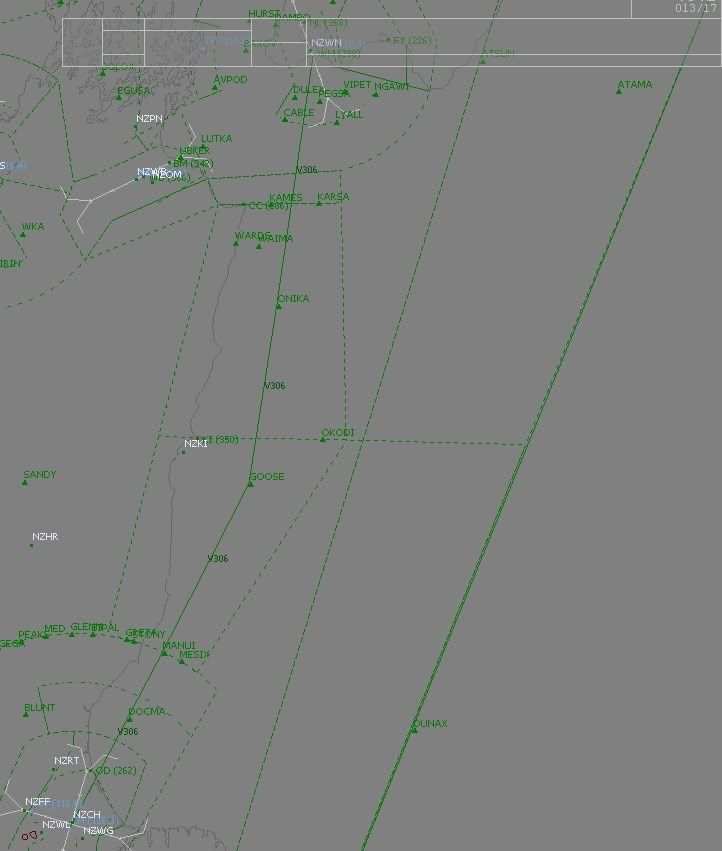
I flew this yesterday on Vatsim. I took off RW34, made a
left hand turn passing 3000 and headed direct to intercept
H159 and then flew to (Karsa) KSA. Then from KSA I flew
Direct (DCT) to GOS, where I then followed airway V306 till
I reached the ILS approach around OD NDB. I'll jump on
my main PC and fire up FS and plot it on FS Nav to show ya.
Matt
Here it is, sorry it's a bit wide
Last edited by ZK-MAT on Sun Nov 19, 2006 5:48 pm, edited 1 time in total.
-

ZK-MAT - Senior Member
- Joined: Sun Apr 30, 2006 11:41 pm
- Posts: 1690
- Location: Papamoa
![]() by Alex » Sun Nov 19, 2006 5:52 pm
by Alex » Sun Nov 19, 2006 5:52 pm
Seems like it is abbreviating some of the intersections, so GOS=GOOSE, KSA=KARSA (I think).
Picture attached below;
Alex
EDIT; Darn it Matt Fast-Fingers.
Picture attached below;
Alex
EDIT; Darn it Matt Fast-Fingers.
Last edited by Alex on Sun Nov 19, 2006 5:53 pm, edited 1 time in total.
- Alex
- NZFF Pro
- Joined: Fri Jul 14, 2006 3:39 pm
- Posts: 3620
![]() by ronindanbo » Sun Nov 19, 2006 6:39 pm
by ronindanbo » Sun Nov 19, 2006 6:39 pm
OK so what I see here is your stuffed on AVSIM unless you have FS Nav or a real powerfull FMC.
-
ronindanbo - Sim-holic
- Topic author
- Joined: Fri Jul 14, 2006 5:59 am
- Posts: 700
- Location: Wellington
![]() by whitei » Sun Nov 19, 2006 6:52 pm
by whitei » Sun Nov 19, 2006 6:52 pm
Guys try this link it is the NZ Air Navigation Register, it has all the routes that are in NZ Airspace.
http://www.caa.govt.nz/airspace/AirNavR ... Routes.pdf
And an example.
In the AIP the route for Wellington to Christchurch is:
H159 KARSA DCT(direct) GOOSE V306
H159 is a two way route so starts at NV and finishes at WN (H159 = NV VOR SW VOR BIDEL REP ....... KARSA REP WN VOR)
In this case we get on at WN VOR and get of at KARSA REP, from KARSA we head direct to GOOSE
GOOSE is also a part of the V306 airway route which is only one way, in this case V306 starts at WN VOR and goes to CH VOR via a few reporting points, So we get on the airway at GOOSE and get of at CH VOR.
Its kind of like getting on and off motorways except these are in the sky.
Hope this makes some sense.
If you need any help give me a yell an I could set up a time on VATSIM to go over it most probably a Thursday night.
Cheers
Ian White
http://www.caa.govt.nz/airspace/AirNavR ... Routes.pdf
And an example.
In the AIP the route for Wellington to Christchurch is:
H159 KARSA DCT(direct) GOOSE V306
H159 is a two way route so starts at NV and finishes at WN (H159 = NV VOR
In this case we get on at WN VOR and get of at KARSA REP, from KARSA we head direct to GOOSE
GOOSE is also a part of the V306 airway route which is only one way, in this case V306 starts at WN VOR and goes to CH VOR via a few reporting points, So we get on the airway at GOOSE and get of at CH VOR.
Its kind of like getting on and off motorways except these are in the sky.
Hope this makes some sense.
If you need any help give me a yell an I could set up a time on VATSIM to go over it most probably a Thursday night.
Cheers
Ian White
- whitei
- Member
- Joined: Sat Sep 30, 2006 12:51 pm
- Posts: 53
- Location: Lincoln
![]() by ZK-MAT » Sun Nov 19, 2006 6:53 pm
by ZK-MAT » Sun Nov 19, 2006 6:53 pm
I think ya mean Vatsim or Ivao 
Surely you can enter the intersections in the GPS? I used to use the GPS before I got FS Nav, and can recall programming the flight plan route in that way. Not all real life planes use fancy FMS systems, they navigate using the VOR's and NDBs.
If you are unsure where to go and there's ATC on ask them for directions. I would put in your comments when you file the flight plan you are unsure of navigation and will require assistance or similar.
Or, grab the chart off AIP, see which direction it tells you to go and set your heading by that, in conjunction with the VOR and NDB signals to work out where you are.
I also suggest getting some GA VFR flights in online if needed to build up the confidence. If only to listen in on the ATC to hear that others will ask questions. There's nothing wrong with asking for clarification about something.
Last edited by ZK-MAT on Sun Nov 19, 2006 6:55 pm, edited 1 time in total.
-
ZK-MAT - Senior Member
- Joined: Sun Apr 30, 2006 11:41 pm
- Posts: 1690
- Location: Papamoa

![]() by ZK-Brock » Thu Nov 30, 2006 8:07 pm
by ZK-Brock » Thu Nov 30, 2006 8:07 pm
Ok, another question. On VATSIm recently, I've been viewing some aircraft's flightplans, and they put only the airway that they are going to use, e.g. V393. How is a controller s'posed to know what the actual route is for this aircraft? They'd have to look up the airway in their AIP, figure out where they are on that airway etc... is it normal to just state an airway as your Flightplan? e.g. SID V393 STAR
B-rockitipu
B-rockitipu
- ZK-Brock
- NZFF Pro
- Joined: Sun Jul 23, 2006 3:35 pm
- Posts: 2035
![]() by Alex » Thu Nov 30, 2006 9:09 pm
by Alex » Thu Nov 30, 2006 9:09 pm
They can see using their ATC program what the route is, for example, a flight from Auckland to Hamilton, and they have entered H211 as their route, a controller can see the airways, like this below;
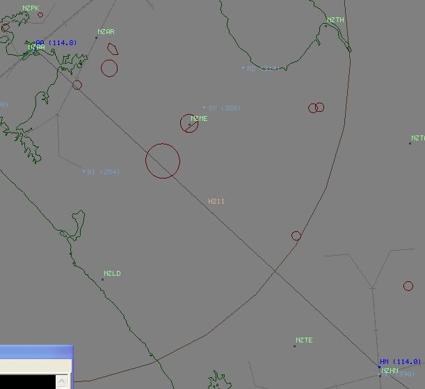
Did you know H211 goes all the way to Napier?
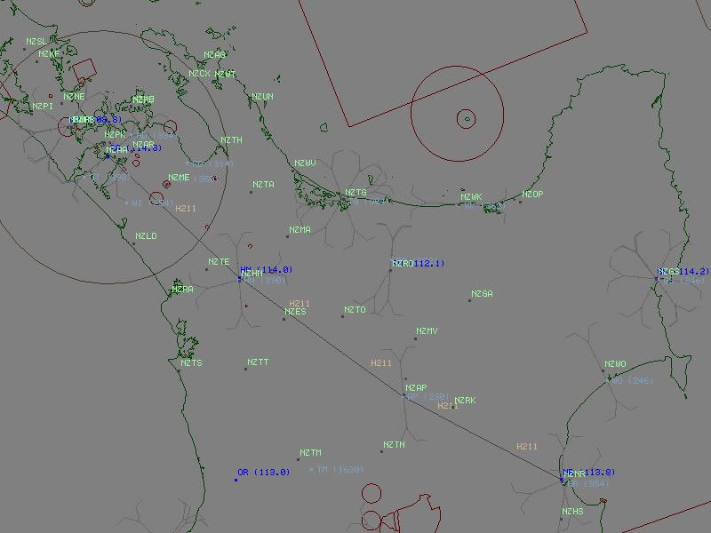
Using IvAc you can see their route by selecting an option from the tag, it 'joins the dots' between the navaids/airways in their route, I am not sure about VRC or ASRC though.
I believe that in cases where it is impractical to go to a navaid or intersection in your flight an airway is acceptable.
Alex
Did you know H211 goes all the way to Napier?
Using IvAc you can see their route by selecting an option from the tag, it 'joins the dots' between the navaids/airways in their route, I am not sure about VRC or ASRC though.
I believe that in cases where it is impractical to go to a navaid or intersection in your flight an airway is acceptable.
Alex
Last edited by Alex on Thu Nov 30, 2006 9:27 pm, edited 1 time in total.
- Alex
- NZFF Pro
- Joined: Fri Jul 14, 2006 3:39 pm
- Posts: 3620
![]() by Alex » Thu Nov 30, 2006 9:21 pm
by Alex » Thu Nov 30, 2006 9:21 pm
Well, it looks similar, except they have paper flightstrips, whereas mine are virtual . I haven't had a play around with the program Airways uses so I probably am not the best judge, what we need now is towerguy to come along and try it out .
Alex
. I haven't had a play around with the program Airways uses so I probably am not the best judge, what we need now is towerguy to come along and try it out .Alex
- Alex
- NZFF Pro
- Joined: Fri Jul 14, 2006 3:39 pm
- Posts: 3620
32 posts
• Page 2 of 2 • 1, 2
Who is online
Users browsing this forum: No registered users and 17 guests