If you only want basic wind speed and direction, that's shown in the flight planning page.
There are loads of free online flight planners that will show METAR information, but I use the *excellent*
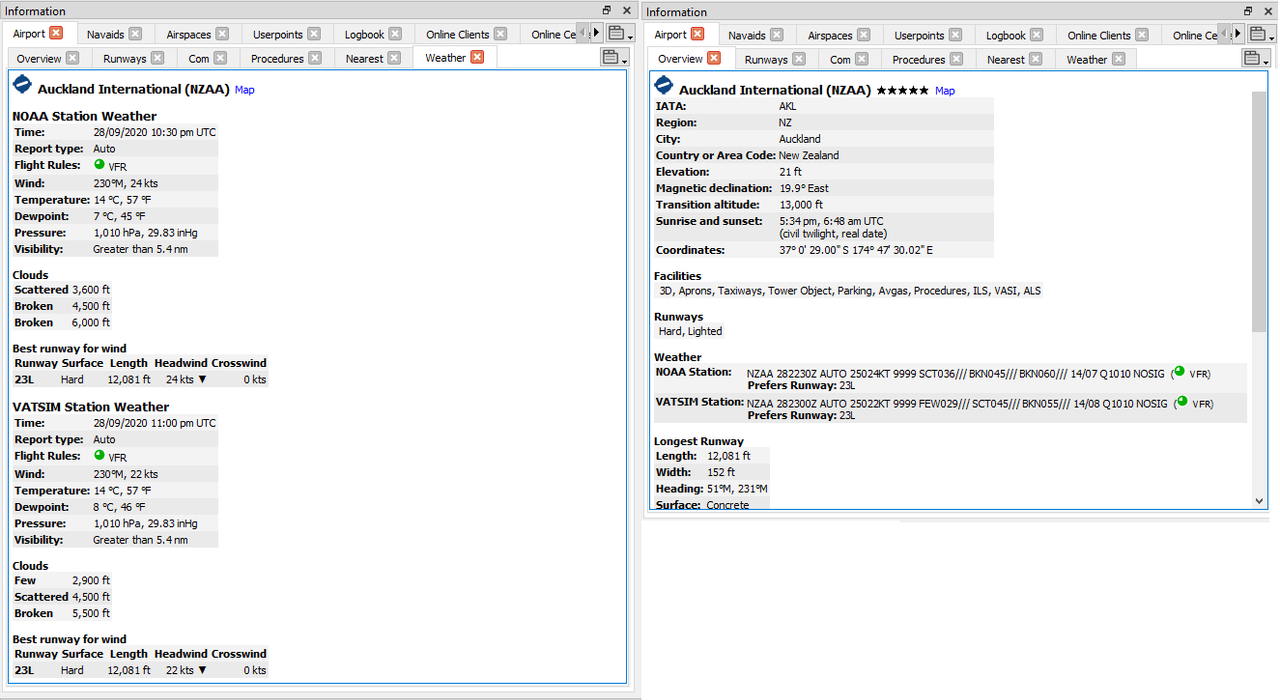
LittleNavMap (that's been updated to work with FS 2020). If you select an airport, you'll get the METAR info in the "Overview" tab, as well as a human-readable equivalent in the "Weather" tab.
https://www.littlenavmap.org/LittleNavMap Docs:
41.1.2. Online - NOAA, VATSIM and IVAO
Online weather from both sources is updated every 10 minutes.
Here's what I've got right now for NZAA (midday):
LittleNavMap:
NOAA Station:
NZAA 282230Z AUTO 25024KT 9999 SCT036/// BKN045/// BKN060/// 14/07 Q1010 NOSIG ( VFR)
Prefers Runway: 23L
VATSIM Station:
NZAA 282300Z AUTO 25022KT 9999 FEW029/// SCT045/// BKN055/// 14/08 Q1010 NOSIG ( VFR)
Prefers Runway: 23L
IVAO Station:
NZAA 282300Z AUTO 25022KT 9999 FEW029/// SCT045/// BKN055/// 14/08 Q1010 NOSIG ( VFR)
Prefers Runway: 23L
 VATNZ
VATNZ:
https://www.vatnz.net/wx/https://www.vatnz.net/airspace/airport/NZAAAirport
Auckland, New Zealand
Report Time
29 Sep 2020 12:00:00 NZDT
(26 minutes ago)
Raw Report
NZAA 282300Z AUTO 25022KT 9999 FEW029/// SCT045/// BKN055/// 14/08 Q1010 NOSIG
Conditions
Winds: 250 degrees at 22 knots
Clouds: Broken clouds at 5500 feet
Ceiling: 2900ft
Temp: 14°c
QNH: 1010hPa
Visibility:Unlimited
Ceiling: 2900ft
Adam.