
Posted:
Tue Sep 16, 2014 10:20 amby Eagleeye
I was looking at Google earth recently and noticed that Martins Bay has a bigger (maybe better) runway nearby. In the below pictures, to the left of the Martins Bay runway you can see this other place but I have no idea
of its name or purpose. I have software for Martins Bay but not the other. Has anyone got any info he would be willing to share. I have flown around that area in the simulator and cant see it. Would be nice to have that
strip in FSX also. Look forward to your replies.
http://www.fsfiles.org/flightsimshotsv2/QAR
Posted:
Tue Sep 16, 2014 10:28 amby Ian Warren
Shows my Ignorance, mind you, there are many strips out there ... if in Southland, this will be picked up immediately by the NZFF Scenery team and probably be done to and with photo-real you before the next time you open a box of WEETBIX

Posted:
Tue Sep 16, 2014 1:04 pmby Roy
Orbx FTX Milford Sound Airport have both runways NZMJ Martins Bay as part of the scenery.
Posted:
Tue Sep 16, 2014 1:15 pmby Ian Warren
Roy wrote:Orbx FTX Milford Sound Airport have both runways NZMJ Martins Bay as part of the scenery.
Thanks Roy, Learned a new part off the NZ I have never been to ..... now who's going to fly me there

.... thought, are they PC wired . not so much into fishing .
Posted:
Tue Sep 16, 2014 1:19 pmby ardypilot
I believe the second airstrip is known as Jerusalem Creek. Local Queenstown operators fly trampers out there who are starting/finishing the Hollyford Track from what I've heard.

Both are included in
Orbx's Milford Sound payware addon.
Posted:
Tue Sep 16, 2014 1:22 pmby Ian Warren
Be Interesting to add photo-reall into this area as well .
Posted:
Tue Sep 16, 2014 4:29 pmby Eagleeye
Yes Ian that is what I would like to see a Godzone Photoreal subscription issue for the southland area. Ardypilot thanks for putting a name to the place, your graphics are stunning, very impressive. I have FSX and have collected all I can lay my hands on for New Zealand.
However my scenery is all VLC and I believe that I can't mix VLC & Orbx?? As a newbie I may be wrong, all help appreciated, cheers.
I just realised that the Jerusalem Creek airstrip may be in my FSX VLC software after all as there are two strips, but they looked too close to each other compared to Google Earth. Wiping egg off face, sorry.
Posted:
Tue Sep 16, 2014 5:39 pmby deeknow
Snap !!! I flew (in the Sim) into one and out of the other just last weekend.
From there went up the the valley and climbed up and over the ridge lines to Milford. Man that's some great country in there.
Posted:
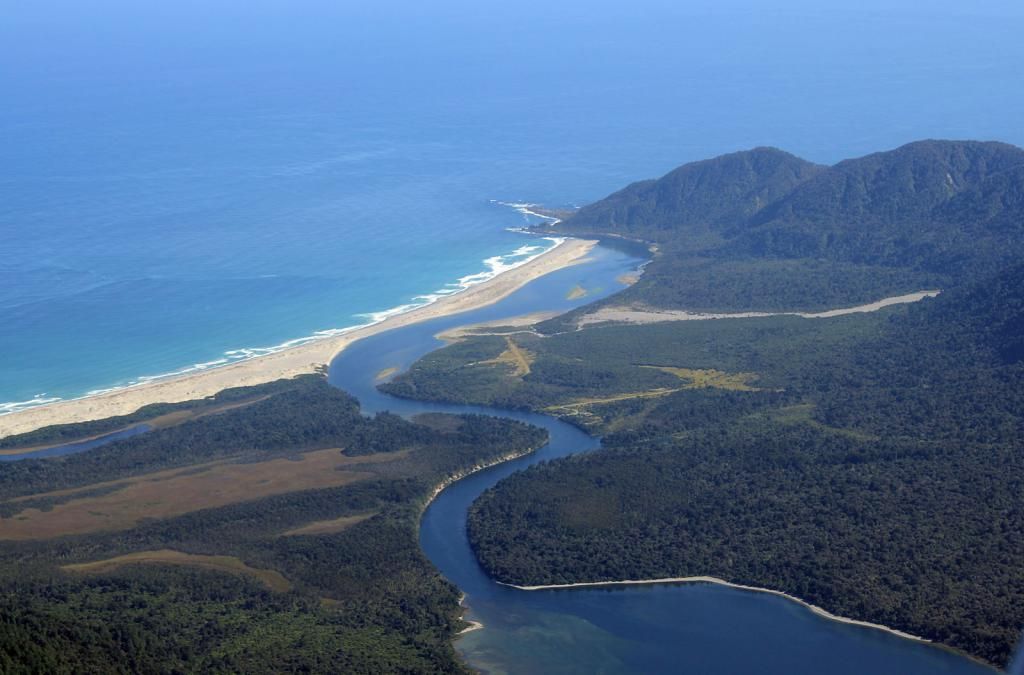
Tue Sep 16, 2014 6:47 pmby FlyingKiwi
Here's a photo of them from earlier this year. I believe the smaller one (closer to the ocean in this shot) is only partially useable due to flooding.
Posted:
Wed Sep 17, 2014 8:39 amby Ian Warren
Now that is almost as real as you can get Leo, one region you really don't have a season change, sweet photo to compare against Andy's screen

!
Posted:
Thu Sep 18, 2014 7:45 pmby CoochB
The airstrip closest to the coast was known as Gunns camp which was the home of local Hollyford valley legend Murray Gunn.
The more inland airship was built by Jules Tapper, another local aviation legend who formed Holly Ford Valley guided walks. The airstrip was used to support this operation.
Both men were fiercely independent and in competition with each other for tourists to support there businesses, hence the reason why in one of New Zealand ' s most remote locations there are 2 airstrips a stones throw from each other.
Posted:
Fri Sep 19, 2014 9:02 amby Ian Warren
CoochB wrote:Both men were fiercely independent and in competition with each other for tourists to support there businesses, hence the reason why in one of New Zealand ' s most remote locations there are 2 airstrips a stones throw from each other.
A feud in the backwoods .. I could almost here the banjos playing the "Defiance theme".
