Just watched this video
http://www.youtube.com/watch?v=K3CUdjBb0EM
I'm not great on navigation.
What approach would that have been following?
NZQN RWY 23 approach
21 posts
• Page 1 of 2 • 1, 2
![]() by FunkymonkeyNZ » Fri Sep 26, 2014 9:34 am
by FunkymonkeyNZ » Fri Sep 26, 2014 9:34 am
Its definitely not the RNP approach, PMDG just cant replicate that but i'll put my bottom dollar on he was using the RNAV G arrival for for Rwy 23
Last edited by FunkymonkeyNZ on Fri Sep 26, 2014 9:47 am, edited 1 time in total.
Chris Maher

NZ CPL(A)+MEIR, NZNV,
NZ CPL(A)+MEIR, NZNV,
-

FunkymonkeyNZ - Forum Addict
- Joined: Sat Sep 22, 2007 10:18 pm
- Posts: 220
- Location: Invercargill
![]() by FunkymonkeyNZ » Fri Sep 26, 2014 10:38 am
by FunkymonkeyNZ » Fri Sep 26, 2014 10:38 am
rocky289 wrote:QUOTE (rocky289 @ Sep 26 2014,10:13 AM) <{POST_SNAPBACK}>So to get onto that, take the ELRU2B approach?
AfirmChris Maher
NZ CPL(A)+MEIR, NZNV,
-
FunkymonkeyNZ - Forum Addict
- Joined: Sat Sep 22, 2007 10:18 pm
- Posts: 220
- Location: Invercargill
![]() by cowpatz » Fri Sep 26, 2014 4:40 pm
by cowpatz » Fri Sep 26, 2014 4:40 pm
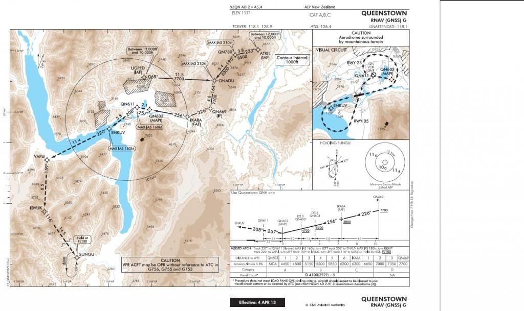
It's all on the chart Nick. The minima is 4100ft. Once at the MAP then follow the visual circuit diagram according to landing runway.
I am not sure most coded approaches ie for PMDG, Majestic or iFly will work because they need to have a runway coded into the procedure. This approach doesn't have that.
I am not sure most coded approaches ie for PMDG, Majestic or iFly will work because they need to have a runway coded into the procedure. This approach doesn't have that.
Remember the 50-50-90 rule. Anytime you have a 50-50 chance of getting something right, there's a 90% probability you'll get it wrong!

-

cowpatz - NZFF Pro
- Joined: Wed Mar 07, 2007 3:28 pm
- Posts: 3371
![]() by FunkymonkeyNZ » Fri Sep 26, 2014 4:47 pm
by FunkymonkeyNZ » Fri Sep 26, 2014 4:47 pm
NZ255 wrote:QUOTE (NZ255 @ Sep 26 2014,4:30 PM) <{POST_SNAPBACK}>Last time I flew the rnav app it dumped me off at about 4000 feet above the field with no where near enough room to get down comfortably....I haven't done it since but am I missing something?
Now that I watch this video again I'm pretty sure this chap didnt follow the appropriate procedure because the approach plate clearly states that for this RNAV approach, once at the MAP you need to break off and go visual either circling around for rwy05 or the figure 8 pattern for rwy23Last edited by FunkymonkeyNZ on Fri Sep 26, 2014 4:52 pm, edited 1 time in total.Chris Maher
NZ CPL(A)+MEIR, NZNV,
-
FunkymonkeyNZ - Forum Addict
- Joined: Sat Sep 22, 2007 10:18 pm
- Posts: 220
- Location: Invercargill
![]() by NZ255 » Fri Sep 26, 2014 6:34 pm
by NZ255 » Fri Sep 26, 2014 6:34 pm
cowpatz wrote:QUOTE (cowpatz @ Sep 26 2014,4:40 PM) <{POST_SNAPBACK}>It's all on the chart Nick. The minima is 4100ft. Once at the MAP then follow the visual circuit diagram according to landing runway.
I am not sure most coded approaches ie for PMDG, Majestic or iFly will work because they need to have a runway coded into the procedure. This approach doesn't have that.
Oh I see! I couldn't figure out how that figure 8 part related to anything!
Thanks, I'll have another go laterNick

-

NZ255 - NZFF Pro
- Joined: Wed Jun 20, 2007 12:57 pm
- Posts: 2475
![]() by nzav8tor » Sat Sep 27, 2014 11:14 am
by nzav8tor » Sat Sep 27, 2014 11:14 am
Theres nothing stopping a request for a visual approach if conditions and traffic permit. It saves alot of time to break off early as shown in the video rather than fly the whole approach and figure 8 if it's not necessary.
-

nzav8tor - Forum Addict
- Joined: Sat Feb 24, 2007 4:31 am
- Posts: 222
- Location: PN
![]() by NZ255 » Sat Sep 27, 2014 11:28 am
by NZ255 » Sat Sep 27, 2014 11:28 am
nzav8tor wrote:QUOTE (nzav8tor @ Sep 27 2014,11:14 AM) <{POST_SNAPBACK}>Theres nothing stopping a request for a visual approach if conditions and traffic permit. It saves alot of time to break off early as shown in the video rather than fly the whole approach and figure 8 if it's not necessary.
If on vatsim how would you request this? There's a video of the 732 from Ch to qn and he requests they cancel their IFR flight plan and proceed VFR, but I think I heard this it's not the correct procedure these days?Nick
-
NZ255 - NZFF Pro
- Joined: Wed Jun 20, 2007 12:57 pm
- Posts: 2475
![]() by Ian Warren » Sun Sep 28, 2014 9:03 am
by Ian Warren » Sun Sep 28, 2014 9:03 am
Least you can its one airport that dose go into favour for "Request visual approach".

-

Ian Warren - NZFF Pro
- Joined: Fri May 05, 2006 5:23 pm
- Posts: 41187
- Location: AREA 51
![]() by cowpatz » Tue Sep 30, 2014 5:13 pm
by cowpatz » Tue Sep 30, 2014 5:13 pm
nzav8tor wrote:QUOTE (nzav8tor @ Sep 30 2014,4:03 PM) <{POST_SNAPBACK}>If conditions permit virtually all commerical IFR traffic in NZ will fly visual approaches. There are specific procedures for AA and WN with visual reporting points.
Except for heavies whereby these days it's the full approach. Some IFR traffic at other airfields like NZPP and NZQN still fly the RNAV or RNP approach track, even though visual, due to separation issues when integrating arriving IFR and VFR traffic . ATC or FSS will know the track of the arriving IFR traffic.Remember the 50-50-90 rule. Anytime you have a 50-50 chance of getting something right, there's a 90% probability you'll get it wrong!
-
cowpatz - NZFF Pro
- Joined: Wed Mar 07, 2007 3:28 pm
- Posts: 3371
![]() by FunkymonkeyNZ » Wed Oct 01, 2014 7:44 pm
by FunkymonkeyNZ » Wed Oct 01, 2014 7:44 pm
rocky289 wrote:QUOTE (rocky289 @ Oct 1 2014,8:33 PM) <{POST_SNAPBACK}>
Just a heads up. You can pull off the NZQN RNP Y Approaches in the Aerosoft Airbus, and might i add very well. just make sure you turn your nav data in the aerosoft control program to navidata pro.Chris Maher
NZ CPL(A)+MEIR, NZNV,
-
FunkymonkeyNZ - Forum Addict
- Joined: Sat Sep 22, 2007 10:18 pm
- Posts: 220
- Location: Invercargill
![]() by NZ255 » Wed Oct 01, 2014 8:44 pm
by NZ255 » Wed Oct 01, 2014 8:44 pm
FunkymonkeyNZ wrote:QUOTE (FunkymonkeyNZ @ Oct 1 2014,8:44 PM) <{POST_SNAPBACK}>in the aerosoft control program to navidata pro.
Navigraph or NavDataPro?Nick
-
NZ255 - NZFF Pro
- Joined: Wed Jun 20, 2007 12:57 pm
- Posts: 2475
21 posts
• Page 1 of 2 • 1, 2
Who is online
Users browsing this forum: No registered users and 0 guests